- Droué
-
Droué
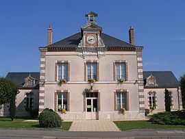
La façade de la mairie de Droué 
Administration Country France Region Centre Department Loir-et-Cher Arrondissement Vendôme Canton Droué
(chef-lieu)Intercommunality Communauté de communes du Perche vendômois Mayor Yves Bertouy
(2008–2014)Statistics Elevation 143–214 m (469–702 ft)
(avg. 158 m/518 ft)Land area1 24.04 km2 (9.28 sq mi) Population2 1,205 (1999) - Density 50 /km2 (130 /sq mi) INSEE/Postal code 41075/ 41260 Website droue.com 1 French Land Register data, which excludes lakes, ponds, glaciers > 1 km² (0.386 sq mi or 247 acres) and river estuaries. 2 Population without double counting: residents of multiple communes (e.g., students and military personnel) only counted once. Coordinates: 48°02′29″N 1°04′38″E / 48.0413888889°N 1.07722222222°E
Droué is a commune in the Loir-et-Cher department of central France.
It is 65 km north-west of Blois and is bordered on the south by the Egvonne, a tributary of the Loir River. The population is 1205 (1999 data).[1]
It is twinned with Rothwell in the United Kingdom and Gondelsheim in Germany.
References
- ^ "Recensement de la population Francaise, Mars 1999". http://www.recensement.insee.fr/RP99/rp99/c_affiche.affiche?nivgeo=C&codgeo=41075&produit=P_POPA&theme=ALL&typeprod=ALL&lang=FR. Retrieved 2008-01-08.
External links
See also
Categories:- Communes of Loir-et-Cher
- Loir-et-Cher geography stubs
Wikimedia Foundation. 2010.


