- São Tomé Island
Infobox Islands
name = São Tomé
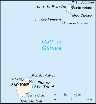
image caption = Map of São Tomé and Príncipe
image size =
locator.jpg)
map_custom = no
native name = "Ilha de São Tomé"
native name link = Portuguese language
nickname =
location =Gulf of Guinea
coordinates = coord|0|14|N|6|36|E|display=inline
archipelago =Bight of Bonny
total islands =
major islands =
area = convert|854|km2|sqmi
length = convert|48|km|mi
width = convert|32|km|mi
highest mount =Pico de São Tomé
elevation = convert|2024|m|ft
country = São Tomé and Príncipe
country admin divisions title = Province
country admin divisions = São Tomé Province
country admin divisions title 1 =
country admin divisions 1 =
country admin divisions title 2 =
country admin divisions 2 =
country largest city =São Tomé
country largest city population = 56,166
population = 133,600
population as of =
density = 156.44
ethnic groups =Mestico , angolares (descendants of Angolan slaves), forros (descendants of freed slaves), servicais (contract laborers from Angola, Mozambique, and Cape Verde), tongas (children of servicais born on the islands), Europeans (primarily Portuguese)
additional info =São Tomé Island, at 854 km² (330 sq mi), is the largest island of
São Tomé and Príncipe and is home to about 133,600 or 96% of the nation's population. This island and smaller nearby islets make up São Tomé Province, which is divided into six districts. The main island is located 2 km (1¼ miles) north of theequator . It is about 48 km (30 miles) long (North-South) by 32 km (20 miles) wide (east-west). It rises to 2,024 m (6,639 ft) atPico de São Tomé and includes thecapital city ,São Tomé , on the northeast coast. The nearest city on mainlandAfrica is the port city ofPort Gentil inGabon located 240 km (150 miles) to the east.Languages
The main language is Portuguese, but there are many speakers of Forro and Angolar (Ngola), two Portuguese-based
creole language s.Geology
The entire island of São Tomé is a massive
shield volcano which rises from the floor of theAtlantic Ocean , over Convert|3000|m|ft|-3|abbr=on below sea level. It formed along theCameroon line , a linearrift zone extending fromCameroon southwest into the Atlantic Ocean. Most of thelava erupted on São Tomé over the last million years has beenbasalt . The youngest dated rock on the island is about 100,000 years old, but numerous more recentcinder cone s are found on the southeast side of the island.Environment and economy
The higher slopes of the island are
forest ed and form part of theObo National Park , butagriculture is important near the north and east coasts. The chief exports arecocoa ,coffee ,copra , and palm products, while there is also afishing industry.Large reserves of
oil are in theocean betweenNigeria and São Tomé. The discovery has been lamented by some as endangering the nation's political stability and natural environment. In response to these concerns the government ofSão Tomé and Príncipe has drawn up legislation in an attempt to ensure the efficient and equitable use of oil revenues over time.Natural history
Birds
The island "boasts" a mere 63 regular bird species, plus an additional 36 vagrant and unconfirmed species. Of these, 19 are endemic and 3 near endemic; in addition, the local
subspecies ofOlive Ibis ("Bostrychia olivacea bocagei") is endemic and considered critically endangered. Six species are considered vulnerable, and two critically endangered (São Tomé Fiscal andSão Tomé Grosbeak ). [http://www.africanbirdclub.org/countries/SaoTome/introduction.html African Bird Club – São Tomé e Príncipe] ]Towns and villages
Villages on the island include:
References
*
* [https://www.cia.gov/library/publications/the-world-factbook/geos/tp.html CIA Word Fact Book]
Wikimedia Foundation. 2010.