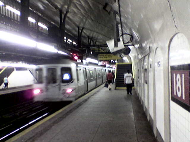
181st Street (IND Eighth Avenue Line)
- 181st Street (IND Eighth Avenue Line)
Infobox NYCS
name = 181st Street

accessible = no
bg_color = #11117D
line = IND Eighth Avenue Line
service = Eighth far north
platforms = 2 side platforms
tracks = 2
passengers = 3.044 million
pass_year = 2006
pass_percent = 2
borough = Manhattan
open_date=September 10, 1932[New York Times, List of the 28 Stations on the New 8th Av. Line, September 10, 1932, page 6] ]
north_station = 190th Street
north_line = IND Eighth Avenue Line
north_service = Eighth far north
south_station = 175th Street
south_line = IND Eighth Avenue Line
south_service = Eighth far north181st Street is a station on the IND Eighth Avenue Line of the New York City Subway. It is located on Fort Washington Avenue and 181st Street, one of the main shopping districts of the Hudson Heights neighborhood of Washington Heights. It is served by the NYCS|A train. The station has two tracks and two side platforms and is deep below the surface due to the area's hills. In fact, the highest natural point on Manhattan is in Bennett Park (New York), a two-minute walk from the station exit on Fort Washington Avenue between West 183rd and 185th Streets (there is no West 184th Street on the hill).
Because of height, elevators at the north end of the station carry passengers to the Bennett Park exit, and escalators lead to 181st Street from the south end of the station. There's an additional exit through the side of the hill leading to Overlook Terrace at the north end, at West 184th Street. (The street exists at lower elevations.) The elevators can be used by pedestrians going between Overlook Terrace and Fort Washington Avenue without paying a fare.
The station serves the surrounding community, as well as Yeshiva University (though the 181st Street station on the IRT Broadway–Seventh Avenue Line is closer).
Bus connections
Fort Washington Avenue exit:
*M4
*M98Overlook Terrace exit:
*M100
*Bx7
Accessibility
:"See also: New York City Subway accessibility"The station is not wheelchair accessible (non-ADA-compliant). The nearest accessible station is 175th Street, also on the (accessible) M4 bus line.
References
External links
* [http://www.nycsubway.org/perl/stations/?7:107 nycsubway.org - IND 8th Avenue: 181st Street]
*Station Reporter — [http://www.stationreporter.net/aleff.htm A Lefferts]
*Station Reporter — [http://www.stationreporter.net/arock.htm A Rockaway]
Wikimedia Foundation.
2010.
Look at other dictionaries:
175th Street (IND Eighth Avenue Line) — Infobox NYCS name = 175th Street accessible = yes bg color = #11117D line = IND Eighth Avenue Line service = Eighth far north platforms = 1 island platform tracks = 2 passengers = 3.747 million pass year = 2006 pass percent = 1 borough =… … Wikipedia
190th Street (IND Eighth Avenue Line) — Infobox NYCS name = 190th Street bg color = #11117D line = IND Eighth Avenue Line service = Eighth far north platforms = 2 side platforms tracks = 2 passengers = 1.243 million pass year = 2006 pass percent = .6 borough = Manhattan open… … Wikipedia
181st Street (станция метро, IND Eighth Avenue Line) — … Википедия
IRT Broadway–Seventh Avenue Line — Broadway–Seventh Avenue Line Метрополитен Нью Йорка Станция South Ferry ныне закрытая станция, расположенная на разворотном круге … Википедия
National Register of Historic Places listings in Manhattan above 110th Street — Main article: National Register of Historic Places listings in New York County, New York List of the National Register of Historic Places listings in Manhattan above 110th Street Map of all coordinates from Google … Wikipedia
168th Street (New York City Subway) — Infobox NYCS name=168th Street bg color=black service = Washington Heights 168th time=1 passengers = 6.705 million pass year = 2006 pass percent = 4 borough=Manhattan accessible=yes acc note=IND Eighth Avenue Line platforms only168th Street is a… … Wikipedia
Dyckman Street — North end Dyckman Street is a street in the Inwood neighborhood of Manhattan, New York City. It is commonly considered to be a crosstown street because it runs from the Hudson River to the Harlem River and intersects Broadway. However, in its… … Wikipedia
Chambers Street (Manhattan) — For other uses, see Chambers Street (disambiguation). Eastern end towards the Manhattan Municipal Building Chambers Street is a bi directional (two way) street in the New York City borough of Manhattan. It runs from River Terrace, Battery Park… … Wikipedia
Fort Washington Avenue (Manhattan) — Fort Washington Avenue is a major north south street in the Washington Heights neighborhood of Manhattan. It runs from Fort Tryon Park to 159th Street, where it intersects with Broadway. It goes past Bennett Park, the highest natural point in… … Wikipedia
New York Subway — Die MTA New York City Subway, auch „New York Subway“ oder einfach „Subway“ genannt, ist das städtische U Bahn Netz der US amerikanischen Stadt New York City. Sie wurde am 27. Oktober 1904 offiziell eröffnet und zählt damit zu den ältesten U… … Deutsch Wikipedia

