- Virginia State Route 244
-
State Route 244
Columbia Pike Route information Maintained by VDOT Length: 8.25 mi[1][2] (13.28 km) Existed: 1933 – present Major junctions West end:  SR 236 in Annandale
East end:  SR 27 at the Pentagon
Highway system Virginia Routes
Primary • Secondary • History • Turnpikes←  SR 243
SR 245  →
→State Route 244, also known as Columbia Pike, is a primary state highway in the U.S. state of Virginia. It is a four-lane road that runs from State Route 236 (Little River Turnpike) in Annandale, Fairfax County east to State Route 27 at the Pentagon in Arlington County.
Contents
History
Columbia Pike dates to 1810 when the U.S. Congress chartered a turnpike Company to build three separate roads through the newly-formed District of Columbia to outlying destinations.[3] One of these roads was to be built through a portion of the District of Columbia that had previously been part of Virginia. This portion was then known as Alexandria County, D.C. (now Arlington County, Virginia). The purpose of this road was to provide access westward from the new Long Bridge that predated the 14th Street Bridge complex to the Little River Turnpike Road, now Virginia State Route 236. The new road was built on a pre-existing cow path as the Washington Graveled Turnpike and was also known as the Washington Road, the Columbian Road, and the Arlington Turnpike.
The U.S. Department of Agriculture paved the road with concrete in 1928 from the bridge west to Palmer's Hill in Barcroft as part of an experimental testing program.

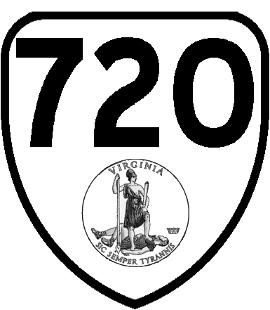
Columbia Pike was first numbered as State Route 720 in 1930 from U.S. Route 1 near the Long Bridge west for around 1 mile (1.6 km). In the 1933 renumbering, it was renumbered State Route 244 and the numbering was extended first to State Route 7 at Bailey's Crossroads and then, between 1934 and 1937, further west to its current terminus at SR 236 in Annandale. With the construction of the Pentagon Columbia Pike was replaced by the Shirley Highway as the Virginia approach to the Long Bridge/14th Street Bridge. By 1944, SR 244 was truncated at the Pentagon; the piece curving away from the original alignment became a state highway in 1964. Until the 1990s, Columbia Pike accommodated rush hour traffic by reversing the direction of one lane using overhead signals. In October 2010, Virginia transferred responsibility for the eastern portion of Columbia Pike to Arlington County.[4]
Contemporary Columbia Pike
The road is a center for Arlington's immigrant community, with many stores, restaurants, and other businesses representing south Arlington's cultural diversity. Also, a weekly farmer's market is held each Sunday during the warmer months of the year. The Pike is intersected by the Four Mile Run Trail and the Washington & Old Dominion Railroad Trail, multi-use trails for pedestrians and cyclists leading northwest to Glencarlyn Park and southeast to Shirlington, at South Four Mile Run Drive.
In 2002, Arlington County adopted the Columbia Pike Initiative, a revitalization plan for the three-and-a-half mile corridor in Arlington. The plan called for development of a high-capacity transit system. The Columbia Pike Initiative was followed in 2003 by adoption of the Form Based Code, which guides development along Columbia Pike. In 2004, the Columbia Pike Street Space Planning Task Force recommended future transit operate in mixed traffic and that the transitway be located in the curb lanes.[5]
Recent efforts by the Columbia Pike Revitalization Organization include the replacement of older traffic signals with newer and more aesthetic ones, and the addition of brick texture to crosswalks. County officials also teamed up with the Washington Metropolitan Area Transit Authority to increase mass transit service along the corridor. This new program called Pike Ride remodeled bus stops and doubled bus frequency along Columbia Pike. In 2006, the Arlington County and Fairfax County Board of Supervisors approved plans of bringing railed streetcars to Columbia Pike along an either a 5 or 6-mile (9.7 km) stretch from the Pentagon to the Skyline area.[5][6]
Major intersections
County Location Mile
[1][2]Destinations Notes Fairfax Annandale 0.00 SR 236 (Little River Turnpike) – Fairfax, AlexandriaWestern terminus Bailey's Crossroads 4.06  SR 7 (Leesburg Pike) – Tysons Corner, Alexandria
Arlington Westmont 6.25  SR 120 (S. Glebe Road) – Chain Bridge, Crystal City
7.28 SR 27 west (Washington Boulevard) – Fort MyerPartial cloverleaf interchange The Pentagon 8.25 SR 27 east (Washington Boulevard) – WashingtonEastern terminus at Rotary Road 1.000 mi = 1.609 km; 1.000 km = 0.621 mi Notes
- ^ a b 2010 Virginia Department of Transportation Jurisdiction Report - Daily Traffic Volume Estimates - Fairfax County
- ^ a b 2010 Virginia Department of Transportation Jurisdiction Report - Daily Traffic Volume Estimates - Arlington County
- ^ An Act to incorporate a company for making certain turnpike roads in the District of Columbia, 2 U.S. Statutes at Large 570 (Apr. 20, 1810). Unfortunately, the date is erroneously given as 1808 in some texts, which has led to confusion. See, e.g., C.B. Rose, Jr., Arlington County, Virginia: A History, p. 76 (1976).
- ^ "Commonwealth Transportation Board Approves Pike Transfer to Arlington". Arlington County. September 16, 2010. http://www.arlingtonva.us/departments/Communications/PressReleases/page78223.aspx. Retrieved December 4, 2010.
- ^ a b News Release: Board Endorses Streetcars for Columbia Pike in official website of the government of Arlington County, VA, April 26, 2006. Accessed May 8, 2009.
- ^ Fairfax Co. Backs Trolley Proposal Along Columbia Pike in wtop.com: official website of WTOP, May 1, 2006. Accessed May 8, 2009.
References
External links
- Virginia Highways Project: VA 244
- Columbia Pike Revitalization Organization
- Arlington's Urban Villages- Columbia Pike
- Washington Post article about proposed street cars along Columbia Pike
- Columbia Pike Transit Initiative
< SR 719 District 7 State Routes
1928–1933SR 721 > Categories:- State highways in Virginia
- Northern Virginia
- Roads in Fairfax County, Virginia
- Transportation in Arlington County, Virginia

Wikimedia Foundation. 2010.