- Araguaia River
Geobox River
name = Araguaia River
native_name = Rio Araguaia
other_name =
image_size = 200
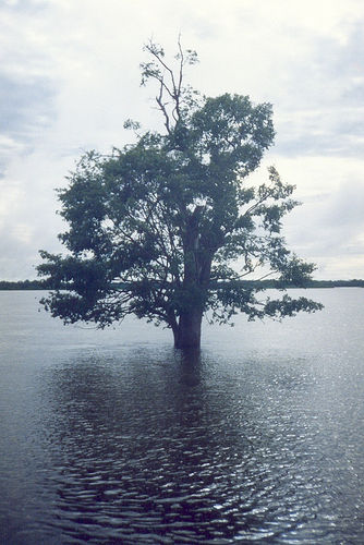
image_caption = A tree in theAraguaia National Park in flood season
country = Brazil
state = Goiás
state1 = Mato Grosso
state2 = Tocantins
state3 = Pará
region =
region1 =
district =
district1 =
city = Aragarças
city1 = Barra do Garças
length = 2627
watershed = 358125
discharge_location = Conceicaodo Araguaia
discharge = 6172
discharge_average_note = (1976-79) [ [http://www.sage.wisc.edu/riverdata/scripts/station_table.php?qual=32&filenum=63 River Discharge Database ] ]
discharge_max =
discharge_min =
discharge1_location =
discharge1 =
source_name =
source_location =
source_district =
source_region =
source_state =
source_country =
source_lat_d =
source_lat_m =
source_lat_s =
source_lat_NS =
source_long_d =
source_long_m =
source_long_s =
source_long_EW =
source_elevation =
source_length =
mouth_name = Tocantins River
mouth_location =
mouth_district =
mouth_region =
mouth_state =
mouth_country =
mouth_lat_d =
mouth_lat_m =
mouth_lat_s =
mouth_lat_NS =
mouth_long_d =
mouth_long_m =
mouth_long_s =
mouth_long_EW =
mouth_elevation =
tributary_left =
tributary_left1 =
tributary_right =
tributary_right1 =
free_name =
free_value =
map_size = 200
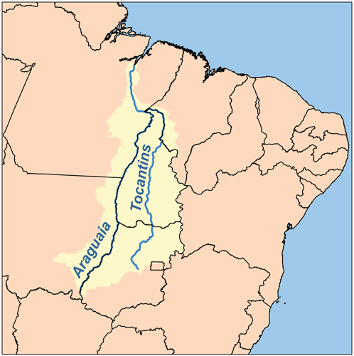
map_caption = Map of the Araguaia/Tocantins WatershedThe Araguaia River or, in Portuguese, "Rio Araguaia" is one of the major rivers ofBrazil , and the principal tributary of the Tocantins. It has a total length of approximately 2,627 km.Geography
Because of the vast number of tributaries, it is not easy to unambiguously define its source. Important tributaries originate in the Araras mountain range in
Mato Grosso as well in the Divisões mountain range situated inGoiás (according to other sources however, the Araguaía comes from the Caiapó Range, at the Goiás-Mato Grosso border). From there it flows northeast to a junction with the Tocantins near the town of São João.Along its course, the river forms the border between the Brazilian federal states of
Goiás ,Mato Grosso , Tocantins andPará . Roughly in the middle of its course, the Araguaia splits into two forks (with the western one retaining the name Araguaia and the eastern one being called "Rio Javaés"). These later reunite, forming theIlha do Bananal , the world's largest river island.A large portion of the Araguaia's course is navigable all year, but the river below Bananal is interrupted by rapids.
The combined watershed of Araguaia and Tocantins rivers (named the "Araguaia Tocantins Basin") covers approximately 9.5 % of Brazil's national territory. This area is an integral part of the
Amazon Basin . However, the Araguaia River is not a tributary of the Amazon."Araguaia" means "River of the
Macaw s" in the nativeTupi language .Tributaries
Its principal tributary is the
Rio das Mortes , which rises in theSerra de Sao Jeronymo , nearCuiabá , Mato Grosso, and is navigable toPará .Other important tributaries include the Bonito, Garcas, Cristallino and Tapirape on the west, and the Pitombas, Claro, Vermelho, Tucupa and Chavante on the east.
History
It was explored in part by
Henri Coudreau in1897 . See Coudreau's Voyage au Tocantins-Araguaya (Paris, 1897).Towns
Among the most important settlements on the banks of the Araguaia River are (in a downstream order):
*Barra do Garças
*Aragarças
*Aruanã
*Luiz Alves
*São Félix do Araguaia
* Santa Terezinha
*Araguacema
*Conceição do Araguaia
*Xambioá
*São Geraldo do Araguaia
*São João do Araguaia Tourism
Several parts of the river's course are protected by national parks and other reserves like the
Emas National Park and theAraguaia National Park . The Araguaia is well-renowned for its scenic beauty, an especially noteworthy feature being its "beaches" - bright sandy banks that seam the stream from May to October. Throughout recent years, certain stretches of the river have become an important destination forecotourism . Along with boat trips, amateur fishing is a popular activity with Brazilian as well as international tourists.However, despite the legal protection that long stretches of the Araguaia enjoy, several development projects present a potential threat to this as of yet largely unspoilt landscape.
References
External links
* [http://www.rioaraguaia.com.br/ "Rio Araguaia (information for tourists in Portuguese, Spanish and English)"]
* [http://www.transportes.gov.br/bit/hidro/detrioaraguaia.htm "hydrographic information (in Portuguese)"]
* [http://www.transportes.gov.br/bit/mapas/mapclick/hidro/bctoca.htm "Basin map (in Portuguese)"]
* [http://www.v-brazil.com/graphics/tocantins.gifTocantins state, with Rivers] v-brazil.com
* [http://www.v-brazil.com/graphics/para.gifPará state, with Rivers] v-brazil.com
Wikimedia Foundation. 2010.