- Matam Region
-
Matam Region
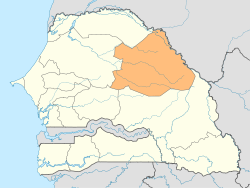
Région de Matam— Region — Location of Matam in Senegal Matam région, divided into 3 départements Coordinates: 15°06′N 13°38′W / 15.1°N 13.633°WCoordinates: 15°06′N 13°38′W / 15.1°N 13.633°W Country Senegal Capital Matam Départements ListArea - Total 25,083 km2 (9,684.6 sq mi) Population - Total 423,041 - Density 16.9/km2 (43.7/sq mi) Time zone GMT (UTC+0) Matam is a region of Senegal (regional capitals have the same name as their respective regions).
It is a stark, flat, arid place bounded on the north by the Sénégal River and the south by the Sahelian plain studded with baobab trees made famous in Le Petit Prince. Matam is populated by the tall noble Pulaar-speaking Toucouleur people who brought Islam to Senegal in the 18th century and gave us the music of Baaba Maal in the 21st century.
Contents
Departments
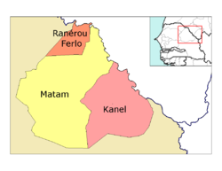
Matam region is divided into 3 departments:
Geography
Matam is traversed by the northwesterly line of equal latitude and longitude.
Cities and Villages
- Agnam-Goly
- Agnam-Civol
- Bokidiawé
- Dabia
- Kanel
- Matam
- Nabbadji Civol
- Ogo
- Oréfondé
- Orkadiére
- Ourossogui
- Ranerou
- Semme
- Sinthiou Bamambé
- Thilogne
- Vélingara
- Waoundé
- Diandioly
- Shinthiou Garba
See also
Regions of Senegal Dakar · Diourbel · Fatick · Kaffrine · Kaolack · Kédougou · Kolda · Louga · Matam · Saint-Louis · Sédhiou · Tambacounda · Thiès · Ziguinchor
 Categories:
- Matam Region
- Regions of Senegal
- Senegal geography stubs
Wikimedia Foundation. 2010.


