- Pelahatchie, Mississippi
Infobox Settlement
official_name = Pelahatchie, Mississippi
settlement_type =Town
nickname =
motto =
imagesize =
image_caption =
image_
imagesize =
image_caption =
image_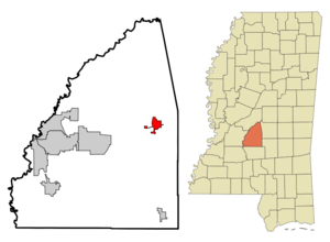
mapsize = 250x200px
map_caption = Location of Pelahatchie, Mississippi
mapsize1 =
map_caption1 =subdivision_type = Country
subdivision_name =United States
subdivision_type1 = State
subdivision_name1 =Mississippi
subdivision_type2 = County
subdivision_name2 = Rankin
government_footnotes =
government_type =
leader_title =
leader_name =
leader_title1 =
leader_name1 =
established_title =
established_date =unit_pref = Imperial
area_footnotes =area_magnitude =
area_total_km2 = 8.3
area_land_km2 = 8.3
area_water_km2 = 0.0
area_total_sq_mi = 3.2
area_land_sq_mi = 3.2
area_water_sq_mi = 0.0population_as_of = 2000
population_footnotes =
population_total = 1461
population_density_km2 = 175.3
population_density_sq_mi = 454.0timezone = Central (CST)
utc_offset = -6
timezone_DST = CDT
utc_offset_DST = -5
elevation_footnotes =
elevation_m = 109
elevation_ft = 358
latd = 32 |latm = 18 |lats = 47 |latNS = N
longd = 89 |longm = 47 |longs = 55 |longEW = Wpostal_code_type =
ZIP code
postal_code = 39145
area_code = 601
blank_name = FIPS code
blank_info = 28-56200
blank1_name = GNIS feature ID
blank1_info = 0675578
website =
footnotes =Pelahatchie is a town in Rankin County,
Mississippi ,United States . The population was 1,461 at the 2000 census. It is part of the Jackson Metropolitan Statistical Area.Pelahatchie means "Crooked Creek " in the Choctaw language.
Geography
Pelahatchie is located at coor dms|32|18|47|N|89|47|55|W|city (32.312941, -89.798648)GR|1.
According to the
United States Census Bureau , the town has a total area of 3.2square mile s (8.3km² ), all of it land.Demographics
As of the
census GR|2 of 2000, there were 1,461 people, 525 households, and 387 families residing in the town. Thepopulation density was 454.0 people per square mile (175.2/km²). There were 585 housing units at an average density of 181.8/sq mi (70.1/km²). The racial makeup of the town was 61.12% White, 36.82% African American, 0.14% Asian, 0.96% from other races, and 0.96% from two or more races. Hispanic or Latino of any race were 4.52% of the population.There were 525 households out of which 30.9% had children under the age of 18 living with them, 47.2% were married couples living together, 20.6% had a female householder with no husband present, and 26.1% were non-families. 22.9% of all households were made up of individuals and 9.9% had someone living alone who was 65 years of age or older. The average household size was 2.77 and the average family size was 3.22.
In the town the population was spread out with 26.2% under the age of 18, 10.9% from 18 to 24, 28.1% from 25 to 44, 23.6% from 45 to 64, and 11.2% who were 65 years of age or older. The median age was 35 years. For every 100 females there were 92.7 males. For every 100 females age 18 and over, there were 93.9 males.
The median income for a household in the town was $31,597, and the median income for a family was $37,313. Males had a median income of $28,145 versus $20,813 for females. The
per capita income for the town was $14,950. About 11.5% of families and 16.0% of the population were below thepoverty line , including 21.9% of those under age 18 and 27.6% of those age 65 or over.Education
The Town of Pelahatchie is served by the
Rankin County School District .Public Schools
*Pelahatchie Elementary School (Grades K-6)
*Pelahatchie High School (Grades 7-12).Private Schools
*East Rankin Academy
References
External links
Wikimedia Foundation. 2010.