- Gulf Hills, Mississippi
Infobox Settlement
official_name = Gulf Hills, Mississippi
settlement_type = CDP
nickname =
motto =
imagesize =
image_caption =
image_
imagesize =
image_caption =
image_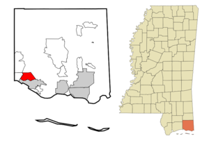
mapsize = 250px
map_caption = Location of Gulf Hills, Mississippi
mapsize1 =
map_caption1 =subdivision_type = Country
subdivision_name =United States
subdivision_type1 = State
subdivision_name1 =Mississippi
subdivision_type2 = County
subdivision_name2 = Jackson
government_footnotes =
government_type =
leader_title =
leader_name =
leader_title1 =
leader_name1 =
established_title =
established_date =unit_pref = Imperial
area_footnotes =
area_magnitude =
area_total_km2 = 20.9
area_land_km2 = 19.6
area_water_km2 = 1.3
area_total_sq_mi = 8.1
area_land_sq_mi = 7.6
area_water_sq_mi = 0.5population_as_of = 2000
population_footnotes =
population_total = 5900
population_density_km2 = 300.7
population_density_sq_mi = 778.7timezone = Central (CST)
utc_offset = -6
timezone_DST = CDT
utc_offset_DST = -5
elevation_footnotes =
elevation_m = 4
elevation_ft = 13
latd = 30 |latm = 26 |lats = 3 |latNS = N
longd = 88 |longm = 49 |longs = 33 |longEW = Wpostal_code_type =
ZIP code
postal_code = 39564
area_code = 228
blank_name = FIPS code
blank_info = 28-29620
blank1_name = GNIS feature ID
blank1_info = 0670768
website =
footnotes =Gulf Hills is a
census-designated place , CDP, in Jackson County,Mississippi ,United States . It is part of thePascagoula, Mississippi Metropolitan Statistical Area. The population was 5,900 at the 2000 census.Gulf Hills is located along the
Mississippi Gulf Coast just south ofInterstate 10 and is bordered by St. Martin (a census-designated place) to the west, Latimer (a census-designated place) to the north and the city of Ocean Springs to the south.Geography
Gulf Hills is located at coor dms|30|26|3|N|88|49|33|W|city (30.434065, -88.825794)GR|1.
According to the
United States Census Bureau , the CDP has a total area of 8.1square mile s (20.9km² ), of which, 7.6 square miles (19.6 km²) of it is land and 0.5 square miles (1.3 km²) of it (6.08%) is water.The terrain in the Bayou Puerto region is relatively high considering its propinquity to the Gulf of Mexico. Elevations range from twenty-five above mean sea level to sea level. The area of interest lies south of the Big Ridge escarpment on the western terminus of an east-west striking coastal ridge, which is sub-parallel to the Big Ridge. Here small bayous and streams have dissected the topography with steep ravines to create a "hilly" terrain. Reconnaissance, surface, geologic investigations indicate that alluvial-fluvial deposits of the Late Pleistocene Prairie "formation" are exposed in the higher areas of the Bayou Puerto-Gulf Hills section. (Otvos, 1972, pp. 223-224) [http://www.oceanspringsarchives.com/GulfHills.htm]
History
Bayou Puerto is the ancestral name for the area that most of us refer to today as Gulf Hills. This small, isolated, primarily Roman Catholic settlement came into existence in the mid-19th century, and encompassed for the most part the S/2 of Section 12, all of Section 13, the E/2 of Section 14, and the NE/4 of Section 24 all of T7S-R9W, Jackson County, Mississippi.
The majority of the people of the Bayou Puerto sector made their livelihoods primarily from the sea and forest. The sea provided fish, crustaceans, and mollusks, as well as the medium for travel and trade. Sylvan dwellers cut timber and light wood and made charcoal. Agriculturally, there were some citrus orchards and viticulture, but large traditional farms were nonexistence. Families cultivated vegetable gardens to supplement their high protein diet consisting primarily of seafood, fowl, and game.
After 1900, there is a marked decrease in charcoal making. Virtually every male resident of Bayou Puerto in 1900 was employed in the seafood industry. Only a few Blacks were still producing charcoal, probably for local consumption. (1900 Federal Census JXCO, Miss.)
Slavery
Slavery in the Bayou Puerto area was almost nil, as most of the inhabitants existed at the subsistence level.
Civil War
No Union incursions occurred in the Bayou Puerto section, nor are there any records of Federal occupation here during the Civil War. Some of the men left the safety and seclusion of their homes to fight for States' Rights against the Union in the War of the Rebellion.
Millionaire's Playground
An event, which permanently changed the history and culture of Bayou-Puerto and St. Martin, occurred as a result of the land boom of the mid-1920s. A group of investors from Chicago and New York enamored with the natural beauty, temperate climate, and propinquity via rail to the "snow birds" of the Midwest, chose an area in eastern St. Martin along and at the mouth of Old Fort Bayou and Bayou Puerto, to build a winter resort. It was called Gulf Hills because small tributaries and intermittent streams flowing into Old Fort Bayou and Bayou Puerto have dissected the topography in the area creating a somewhat rugose topography.
Harvey W. Braniger (1875-1953), a native of Morning Sun, Iowa and developer of Ivanhoe at Chicago, is generally considered the founder of Gulf Hills. A charter of incorporation was issued for Gulf Hills by the State of Mississippi on September 15, 1925. (The Jackson County Times, September 19, 1925, p. 2) [http://www.oceanspringsarchives.com/GulfHills.htm]
The Chicago developers envisioned selling three-acre homesites to wealthy northerners who would come to escape winter's cold blasts, then peacefully retire here.
The Branigars hosted a gala early January 1927 opening of Gulf Hills on No. 1 tee. Billed as the golf city of the Gulf Coast, Gulf Hills covered convert|667|acre|km2|1 with 249 of them dedicated as fairways, parks, playgrounds and waterways. Of the ten miles (16 km) of narrow roadways, four of them were waterfront and seven, on the golf course.
The Depression put the skids to the program. By the end of World War II, there were only 40 homes. By the 1950s, homes were being built again in Gulf Hills. Activity heightened in the 1960s and continued into the 1980s.
The Gulf Hills Inn was revitalized by renaming it Gulf Hills Dude Ranch and creating a western atmosphere. Gulf Hills became a popular place with nationwide recognition. Stars like Judy Garland, Elvis Presley and honeymooning Mary Ann Mobley and Gary Collings adopted the resort as a retreat. Until the 1970s, Mafia bosses would annually gather for business and pleasure. They were so unobtrusive and looked like other golfing businessmen that few people realized they were there. [http://www.co.jackson.ms.us/GIPages/HistoryPics/JCCommunties/GulfHills.htm]
Presently most people live in Gulf Hills all year round not just in the winter, and it is no longer only for the wealthy. A diverse group now occupies this once resort community. Although, most people that live in the quiet little community of Gulf Hills are wealthy or considered, "old money."
Demographics
As of the
census GR|2 of 2000, there were 5,900 people, 2,199 households, and 1,662 families residing in the CDP. Thepopulation density was 778.7 people per square mile (300.5/km²). There were 2,436 housing units at an average density of 321.5/sq mi (124.1/km²). The racial makeup of the CDP was 81.64% White, 10.61% African American, 0.19% Native American, 5.83% Asian, 0.02% Pacific Islander, 0.47% from other races, and 1.24% from two or more races. Hispanic or Latino of any race were 2.02% of the population.There were 2,199 households out of which 34.6% had children under the age of 18 living with them, 60.9% were married couples living together, 10.2% had a female householder with no husband present, and 24.4% were non-families. 18.4% of all households were made up of individuals and 6.1% had someone living alone who was 65 years of age or older. The average household size was 2.67 and the average family size was 3.04.
In the CDP the population was spread out with 25.3% under the age of 18, 8.4% from 18 to 24, 29.7% from 25 to 44, 24.1% from 45 to 64, and 12.5% who were 65 years of age or older. The median age was 37 years. For every 100 females there were 96.5 males. For every 100 females age 18 and over, there were 95.4 males.
The median income for a household in the CDP was $49,250, and the median income for a family was $54,418. Males had a median income of $34,243 versus $23,377 for females. The
per capita income for the CDP was $21,759. About 4.7% of families and 5.0% of the population were below thepoverty line , including 6.1% of those under age 18 and 2.0% of those age 65 or over.Education
Gulf Hills is served by the
Ocean Springs School District .References
External links
Wikimedia Foundation. 2010.