Cheshire Gritstone Trail

Cheshire Gritstone Trail
Stile on the Gritstone Trail - geograph.org.uk - 258304.jpg
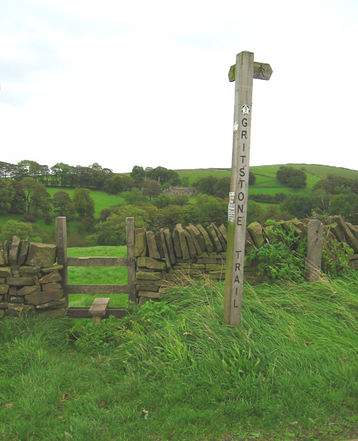
Stile on the Gritstone Trail near Tegg's Nose
Length 35 miles (56 km)
Location Northern England
Trailheads Disley, Cheshire
Kidsgrove, Staffordshire
Use Hiking
Highest point Sponds Hill, 410 m (1,345 ft)[1]
Hazards Stiles

The Cheshire Gritstone Trail is a long-distance footpath in England split into three stages. The first stage, 10.3 miles (17 km) in length, leads from Disley to Tegg's Nose; the second, of length 15.3 miles (25 km), from Tegg's Nose to Timbersbrook, is the best for obtaining a close look at gritstone scenery. The final stage of 9.3 miles (15 km) runs from Timbersbrook to Kidsgrove.

The trail is waymarked with yellow discs with a footprint inscribed 'G'.

See also

References

  1. ^ Discover Cheshire

External links

Coordinates: 53°9′46″N 2°9′16″W / 53.16278°N 2.15444°W / 53.16278; -2.15444


Wikimedia Foundation. 2010.

Игры ⚽ Нужно сделать НИР?

Look at other dictionaries:

  • Recreational walks in Cheshire — There are 1,864 milescite web | title=Public Rights of Way| work=Cheshire County Council | url=http://www.cheshire.gov.uk/countryside/Walking/index.htm | accessdate=2007 01 27] (3,000 km) of public rights of way in Cheshire, England.The following …   Wikipedia

  • Places of interest in Cheshire — This is a list of places of interest in Cheshire. See List of places in Cheshire for a list of settlements in Cheshire.Places of interestCountry parks, gardens and accessible open spaces*Bickerton Hill *Daresbury Firs *Delamere Forest *The Edge,… …   Wikipedia

  • Tegg's Nose — Infobox Mountain Name = Tegg s Nose Photo = Teggs Nose Ridgegate.jpg Caption = Tegg s Nose from Ridgegate Reservoir Elevation = 380 m (1246 ft) Location = Cheshire, England Range = Peak District Prominence = Coordinates = Topographic OS Outdoor… …   Wikipedia

  • Long-distance footpaths in the United Kingdom — The following long distance footpaths can be found in the United Kingdom:England and Wales: National TrailsNational Trails are distinguished by being maintained by the National Trails organization [http://www.nationaltrail.co.uk/] . As of|April… …   Wikipedia

  • White Nancy — This article is about the Cheshire landmark. For the variety of flowering plant named White Nancy see Lamium maculatum White Nancy is a well known local landmark in the town of Bollington, Cheshire, which is used as the logo for the town.… …   Wikipedia

  • Macclesfield Forest — is an area of woodland, predominantly conifer plantation, located around 5 km (3 miles) south east of Macclesfield in the civil parish of Macclesfield Forest and Wildboarclough, in Cheshire, England. The existing woodland is the last substantial… …   Wikipedia

  • Peak District — Geobox|Protected Area name = Peak District native name = other name = other name1 = category local = National Park of England category iucn = V |240px image size = image caption = Peak District entrance stone on Hathersage Road, Sheffield country …   Wikipedia

  • New Mills — For other uses, see New Mills (disambiguation). Coordinates: 53°22′01″N 2°00′25″W / 53.367°N 2.007°W / 53.367; 2.007 …   Wikipedia

  • Derbyshire — For other uses, see Derbyshire (disambiguation). Coordinates: 53°8′N 1°36′W / 53.133°N 1.6°W / 53.133; 1.6 …   Wikipedia

  • Pennines — Not to be confused with Pennine Alps. The Pennine Mountains of Northern England …   Wikipedia

Share the article and excerpts

Direct link
Do a right-click on the link above
and select “Copy Link”