- Ano Liosia
-
Ano Liosia
Άνω Λιόσια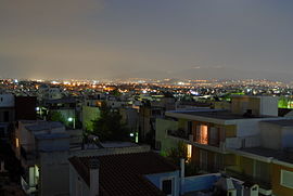
View of Athens from Ano LiosiaLocation 
 Ano Liosia
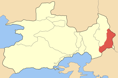
Coordinates 38°5′N 23°42′E / 38.083°N 23.7°ECoordinates: 38°5′N 23°42′E / 38.083°N 23.7°E Location within the regional unit
Government Country: Greece Region: Attica Regional unit: West Attica Municipality: Fyli Population statistics (as of 2001) Municipal unit - Population: 26,423 - Area: 38.447 km2 (15 sq mi) - Density: 687 /km2 (1,780 /sq mi) Other Time zone: EET/EEST (UTC+2/3) Elevation (center): 160 m (525 ft) Postal: 133 xx Telephone: 210 Auto: Z Website www.liosia.gr Ano Liosia (Greek: Άνω Λιόσια) is a suburb and a former municipality in the northern part of the Athens agglomeration, Greece. Since the 2011 local government reform it is part of the municipality Fyli, of which it is the seat and a municipal unit.[1]
Ano Liosia has grown rapidly over the last twenty years. A large number of Roma live in this suburb of the Greek capital.
Contents
Geography
Ano Liosia lies in the eastern part of West Attica, east of Eleusina, SE of Thiva, SSE of Chalkida, and about 15 km N of Athens. Ano Liosia except for the northwest and the southwest were mainly made up of farmlands. The mountain range of Aigaleo is to its southwest. Pasture farming, groves and mixed farming were common. Urban development replaced much of the farmland between the 1970s and the 1990s. Today, half of the municipal unit is urbanized or residential. Rocky landscape with bushes dominates the rest of the land.
Sports teams
- Akratitos - a Greek football/soccer team which was founded in 1963
- Das Ano Liosia - a Greek basketball team
Sites of interest
- Ano Liosia Olympic Hall where wrestling and judo were played in the 2004 Summer Olympics
- Stadium for Akratitos rarely plays in this stadium
- Basketball stadium for Das Ano Liosia
- Football/soccer stadium for Akratitos
Transportation
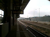 Ano Liosia Proastiakos station
Ano Liosia is connected to the rest of Athens by various bus lines, most notably the B12 and E42 lines, as well as by the Proastiakos rail network. The motorway Attiki Odos runs south of the town, and GR-1/E75 to the east. A suburban railway station has been constructed at Fyli Interchange of Attiki Odos with Fylis Avenue. The station is part of the new railroad line between Athens and Patras. The railway station on the old metric line is now closed.
Other
Ano Liosia has schools, lyceums, gymnasia, banks, a police station, a post office, supermarkets, a recycling plant, parks and squares (plateies).
History
Ano Liosia was rebuilt after World War II and the Greek Civil War.
On September 7, 1999, the 1999 Athens earthquake damaged between one hundred and a thousand homes. The 11th International Chess Tournament took place in Ano Liosia in 2001. The municipality opened a campsite in 2002 outside the town at Myrsini Beach northwest of Myrsini in the northwestern part of the Prefecture of Ilia. It is known as LM Beach.
The havoc of the nearby Parnitha fire (See also: Summer 2007 Wildfires in Greece) devastated the northern portion of the area and nearly devastated the city. The fire reached the outskirts of the town during the evening of 28 June 2007 and was seen throughout the night. It calmed down on 30 June. Approximately 50 square kilometres were laid waste.
Population
Year Population 1981 16,862 1991 21,397 2001 26,423 References
- ^ Kallikratis law Greece Ministry of Interior (Greek)
External links
- City of Ano Liosia official website (Greek)
- http://www.chess.gr/anoliosia/
- http://www.stadia.gr/anoliossia/anoliossia.html
Northwest: Fyli North: Fyli and Acharnes Northeast: Acharnes West: Aspropyrgos Ano Liosia East: Acharnes South: Kamatero and Petroupoli Southeast: Zefyri Municipal units Categories:- Populated places in West Attica
- Romani communities in Greece


Wikimedia Foundation. 2010.