- Morąg
-
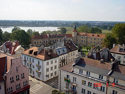
Morąg Town view 
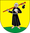
Coat of armsCoordinates: 53°55′N 19°56′E / 53.917°N 19.933°E Country  Poland
Voivodeship Warmian-Masurian County Ostróda Gmina Morąg Established 13th century Town rights 1327 Government - Mayor Tadeusz Zbigniew Sobierajski Area - Total 12.17 km2 (4.7 sq mi) Population (2006) - Total 14,497 - Density 1,191.2/km2 (3,085.2/sq mi) Time zone CET (UTC+1) - Summer (DST) CEST (UTC+2) Postal code 14-300, 14-331 Area code(s) +48 89 Car plates NOS Website http://www.morag.pl Morąg [ˈmɔrɔŋk] (German: Mohrungen (
 listen), Lithuanian: Maurungėnai) is a town in northern Poland in Ostróda County in the Warmian-Masurian Voivodeship about 60 km (37.28 mi) south of the Polish - Russian border. The nearest city is Olsztyn, 44 km to the southeast.
Contents
History
The town was founded as Mohrungen by the Teutonic Knights in 1302 in eastern Prussia and in 1327 attained Kulm law from Hermann von Oettingen. The original inhabitants of the town were emigrants from the southern Harz. The War between the Teutonic Order and Poland saw the town incinerated completely in 1414. Mohrungen was occupied by the Grand Duchy of Lithuania and the Kingdom of Poland from 1410 to 1461.
Mohrungen was on a shipping commerce line connecting Truso with harbors at the Black Sea. Agriculture and commerce was the primary occupations in the town. It was known as a cattle and grain market.[1]
From 1525 to 1701 Mohrungen was part of Ducal Prussia and became part of the Kingdom of Prussia in 1701. It was the seat of the district administration of Landkreis Mohrungen since 1752. An earthquake struck the town in 1818. Until 1945 Mohrungen belonged to Germany. After World War II the local populace was expelled and the town became part of Poland as Morąg.
Since May 2010 the town is the garrison of a US Army Patriot Missile Defense battery.[2]
Sights
After a fire in 1697 only the castle and the church, which was restored and rebuilt several times, survived. Following World War II in 1945 fires burnt about 45% of the town. Only the outer walls of the town hall remained.
- The old castle of the Teutonic Knights is being excavated as more of it has been recently discovered.
- The "Schlößchen" (Little Palace), which was mostly destroyed in the Second World War, was restored in 1986.
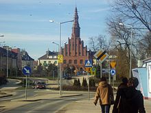
- The main body of the Catholic church of Saint Peter and Saint Paul goes back to the first half of the 14th century.
- The town hall, damaged in the Second World War, was rebuilt from 1947-1954 as it looked before.
- Some ruins of the original town walls still remain.
- Kretowiny, a popular lake and camp ground are only 9 km away and are a favorite and frequent retreat for the local population.
- It has an impressive regional museum.[3]
Population
-
- 1740: 1,067
- 1782: 1,753
- 1820: 2,108
- 1880: 3,742
- 1885: 3,879
- 1890: 3,780
- 1900: 4,025
- 1910: 4,147
- 1925: 4,934
- 1933: 5,414
- 2003: 14,570
Famous residents
- Christoph von Dohna (1583–1637), politician
- Abraham Calovius (1612–1686), Lutheran theologian
- Johann Gottfried von Herder (1744–1803), author, Lutheran theologian, and eminent enlightenment philosopher
- Friedrich von Zander (1791–1868) Prussian Chancellor
- Elisabeth von Thadden (1890–1944), educator
- Reinold von Thadden-Trieglaff (1891–1976), theologian
- Gerhard Bondzin (born 1930), painter - Gallery
- Bernd Heine (born 1939), linguist
- Zbigniew Nienacki (1929–1994), Polish writer
- Cezary Worek (1965- ), researcher at the AGH University of Science and Technology in Kraków
References
- ^ Cohen, Saul B., "The Columbia Gazetteer of the World." Columbia University Press, 1998.
- ^ Poland welcomes US soldiers, Patriot missiles
- ^ Bousfield, Jonathan and Salter, Mark, "The Rough Guide to Poland, 6th edition," Rough Guides, New York, 2008. Page 229.
External links
- Municipal website (Polish)
Coordinates: 53°55′N 19°56′E / 53.917°N 19.933°E
Town and seat MorągVillages Anin • Antoniewo • Bartężek • Białka • Bogaczewo • Borzymowo • Bożęcin • Bramka • Chojnik • Dobrocinek • Dury • Dworek • Gubity • Gulbity • Jędrychówko • Jurecki Młyn • Jurki • Kadzianka • Kamionka • Kępa Kalnicka • Kretowiny • Królewo • Kruszewnia • Kudypy • Łączno • Lubin • Lusajny Małe • Maliniak • Markowo • Morzewko • Niebrzydowo Małe • Niebrzydowo Wielkie • Nowy Dwór • Obuchowo • Piłąg • Plebania Wólka • Prętki • Prośno • Raj • Rogowo • Rolnowo • Ruś • Silin • Słonecznik • Stabuniki • Strużyna • Szczuplinki • Szymanowo • Tątławki • Wenecja • Wilnowo • Wola Kudypska • Worytki • Woryty Morąskie • Żabi Róg • Zawroty • Zbożne • Złotna • ZwierzyniecCategories:- 1302 establishments
- Castles of the Teutonic Knights
- Cities and towns in Warmian-Masurian Voivodeship
- Ostróda County
- Populated places established in the 1300s
Wikimedia Foundation. 2010.


