Church Island, River Thames
- Church Island, River Thames
-
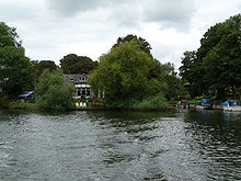
The tail of Church Island
Church Island is an island in the River Thames in England on the reach above Penton Hook Lock, near Staines Bridge in Staines, Spelthorne, Surrey. It connects by a footbridge to Church Street, Staines, near a recreation ground.
Roman Bridges across the Thames were built here soon after the invasion of Claudius in 43 AD. The Roman name for Staines was "ad Pontes" (plural "at the bridges") implying that there was more than one bridge. It is believed that these bridges crossed the River Colne and the Thames via Church Island.[1]
References
- ^ Fred. S. Thacker The Thames Highway: Volume II Locks and Weirs 1920 - republished 1968 David & Charles
See also
Coordinates: 51°26′06″N 00°31′12″W / 51.435°N 0.52°W / 51.435; -0.52
Categories:
- Surrey geography stubs
- Islands of the River Thames
Wikimedia Foundation.
2010.
Look at other dictionaries:
Church Island — For the island in the River Thames at Staines, see Church Island, River Thames. Coordinates: 53°13′21.9″N 4°10′16.6″W / 53.22275°N 4.171278°W / … Wikipedia
River Thames — Thames redirects here. For other uses, see Thames (disambiguation). Coordinates: 51°29′56″N 0°36′31″E / 51.4989°N 0.6087°E / 5 … Wikipedia
Islands in the River Thames — This article lists the islands in the River Thames, in England. It excludes many of the smaller lock islands that were created when weirs and locks were built, and also some very small islands that immediately adjoin the larger ones. The Isle of… … Wikipedia
River Don, South Yorkshire — River Don The River Don as it flows past Hillsborough Stadium. Origin Pennines … Wikipedia
River Cherwell — Coordinates: 51°44′32″N 1°14′54″W / 51.74222°N 1.24833°W / 51.74222; 1.24833 … Wikipedia
Thames Ditton — infobox UK place country = England latitude=51.39479 longitude= 0.34125 official name= Thames Ditton map type= Surrey population = 5,863 [ [http://neighbourhood.statistics.gov.uk/dissemination/LeadKeyFigures.do?a=7 b=5943027 c=Thames+Ditton d=14… … Wikipedia
River Brent — Geobox|River name = Brent native name = other name = other name1 = image size = image caption = Brent River at Brentford etymology = country country = England country1 = state = state1 = region type = Counties region = Greater London region1 =… … Wikipedia
River Effra — The River Effra is a river in south London, England. It is now underground. The name is derived from the Celtic word for torrent (e.g. ffrydlif in current Welsh) given by the pre Roman tribes (see Peter Akroyd s The Thames ).When the London… … Wikipedia
Church of San Giorgio Maggiore — San Giorgio Maggiore seen across the water in full sun on an evening in June Church of San Giorgio Maggiore … Wikipedia
Canvey Island — infobox UK place country = England official name= Canvey Island static static image caption= Canvey Island s seawall and the adjacent environments at Leigh Beck. latitude= 51.5171 longitude= 0.5784 population = 37,479 shire district= Castle Point … Wikipedia

