- Cardiff Heliport
Infobox Airport
name = Cardiff Heliport
nativename = Tremorfa Heliport
nativename-a =
nativename-r =
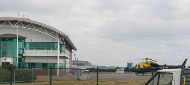
image-width =
caption =
IATA = N/A
ICAO = EGFC
type = Public
owner =Cardiff Council
operator = Veritair aviation Ltd
city-served =Cardiff
location =Tremorfa ,Cardiff
elevation-f =
elevation-m =
coordinates = coord|51|28|7.03|N|03|08|16.9|W|type:airport|display=inline
website = [http://www.veritair.com]
metric-rwy =
h1-number =
h1-length-f = 984
h1-length-m = 300 [ [http://www.ebanmagazine.com/hb_airportpage.html?recnum=2985 www.ebanmagazine.com runway length] ]
h1-surface =Concrete
stat-year =
stat1-header =
stat1-data =
stat2-header =
stat2-data =
footnotes =Cardiff Heliport Airport codes|N/A|EGFC is a heliport located in
Tremorfa ,Cardiff ,Wales , approximately 2 miles (3.22 km) from the city centre.The heliport is owned by
Cardiff Council , but Veritair Ltd (trading as British International) (now VERITAIR AVIATION)have a long term lease on the facility [ [http://www.cardiff.gov.uk/content.asp?Parent_Directory_id=2865&nav=2870,4048,4185,4595 Cardiff Council] ] . The heliport cost £3.8 million to build and was the operating base for theSouth Wales Police helicopter. But the heliport can also handle considerable passenger traffic too, especially during major sporting events at theMillennium Stadium . It can handle over 180 movements in a single day with up to 40 aircraft parked at any one time [ [http://www.execdigital.co.uk/British-International_285.aspx Exec Digital information on British International] ] .The South Wales Police contract involving 2 Twin Squirrel AS355F2 aircraft (G-SEWP and G-SYPA) ended on 31st January 2008, when the contract transferred to Bond Helicopters operating EC135 aircraft at a new base at St Athan, Vale of Glamorgan.
In May 2008 the business of British International at Cardiff was sold to the management team lead by Captain Julian Verity.the new company is called Veritair aviation
Plans have been announced to create a PPL(H) Flight Training School based on Robinson aircraft and it is said that Avgas will be available later in the summer.
Aircraft chiefly operating from Cardiff are AS355N G-STON, AS355F2 G-SEWP, BO105bd4 G-BTKL and Bell 407 G-OZAC, owned by HeliLux/GRYPHON AVIATION.
Notes
External links
* [http://www.cardiff.gov.uk/content.asp?Parent_Directory_id=2865&nav=2870,4048,4185,4595 Cardiff Council]
* [http://www.helilux.com HeliLux]
Wikimedia Foundation. 2010.