- Hardangervidda
Infobox_protected_area | name = Hardangervidda National Park
iucn_category = II
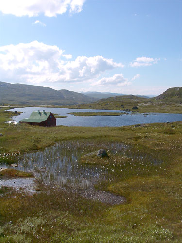
caption = Hardangervidda landscape
locator_x =
locator_y =
location =Buskerud ,Hordaland , andTelemark ,Norway
nearest_city = Bergen
lat_degrees = 60
lat_minutes = 3
lat_seconds = 0
lat_direction = N
long_degrees = 7
long_minutes = 25
long_seconds = 0
long_direction = E
area = 3422 km²
established = 1981
visitation_num =
visitation_year =
governing_body = Directorate for Nature ManagementThe Hardangervidda is a mountain plateau ("vidda" in Norwegian) in the
Hardanger region of westernNorway . It is the largest such plateau in Europe, with a cold year-roundalpine climate and is the site of one of Norway's largestglacier s. Much of the plateau is protected as part ofHardangervidda National Park ; it is a popular tourist and leisure destination for many outdoor activities. The region is divided administratively between the counties ofBuskerud ,Hordaland , andTelemark .Geography and geology
The plateau is the largest
peneplain (eroded plain) inEurope , covering an area of about convert|6500|km2|sqmi|-2|abbr=on at an average elevation of 1,100 m (3,500 ft). The highest point on the plateau is at the top of theHardangerjøkulen glacier, which reaches a height of convert|1863|m|ft|0|abbr=on.The landscape of the Hardangervidda is characterised by barren, treeless moorland interrupted by numerous pools, lakes, rivers and streams. There are significant differences between the west side, which is dominated by rocky terrain and expanses of bare rock, and the east side, which is much flatter and more heavily vegetated. The climate also varies between the two sides: it is considerably wetter on the west side than on the east, with over 1,000 mm per year (39 inches) recorded in some parts."The Halne Area, Hardangervidda. Use of a High Mountain Area during 5000 Years - An Interdisciplinary Case Study", Dagfinn Moe, Svein Indrelid & Arthur Fasteland, in "The Cultural Landscape: Past, Present and Future", ed. Hilary H. Birks] The prominent peak of
Hårteigen convert|1690|m|ft|0|abbr=on is visible across much of the plateau.Much of the Hardangervidda's geology is extremely ancient. The rolling fells of the Hardangervidda are the remnants of mountains that were worn down by the action of glaciers during the
Ice Ages . The bedrock is mainly ofPrecambrian and Cambro-Silurian origin.Flora and fauna
The whole of the Hardangervidda is above the
tree line . Its alpine climate enables the presence of many species ofarctic animals and plants further south than anywhere else in Europe, including thearctic fox ,Snowy Owl , and others. Its wildreindeer flocks are among the largest in the world, with some 15,000 animals recorded in 1996. They migrate across the plateau during the year, moving from their winter grazing lands on the east side of the Hardangervidda, where they graze onlichen , to their breeding grounds in the more fertile west of the plateau.The varying climate of the plateau has a marked effect on the flora, which is richer on the wetter west side than in the drier east; much of the plateau is covered by coarse
grass es,moss es (especiallysphagnum ) and lichens.In the
stone age , 9000 - 5000 years ago, the regional climate was warmer, and large parts of Hardangervidda were wooded; pine logs can still be found preserved in bogs well above todays treeline. With the predicted warming, Hardangervidda could again be largely wooded ( [http://www.bjerknes.uib.no/pages.asp?id=7&kat=2&lang=1 ] ).Museum
The national park has two museums and visitor centres: the
Hardangervidda Natursenter (Nature Centre) inEidfjord , and the Hardangervidda Nasjonalparksenter (National Park Centre) inTinn , near the lakeMøsvatnet .Human settlement
The Hardangervidda has been occupied for thousands of years; several hundred nomadic stone age settlements have been found in the area, most likely related to the migration of the reindeer. Ancient trails cross the plateau, linking western and eastern Norway. One example is the "Nordmannsslepa" linking Eidfjord and Veggli in the Numedal valley with Hol and Uvdal. It is still a key transit route between
Oslo andBergen . TheBergensbanen railway line and the main Highway 7 cross the plateau.National park
In 1981, much of the Hardangervidda was designated a
national park , Norway's largest at 3,422 km² (1,321 square miles). The park's boundaries stretch fromNumedal andUvdal in the east andRøvelseggi andUllensvang in the west. TheNorwegian Mountain Touring Association (DNT) maintains a comprehensive network of huts and paths across the plateau. It is a popular destination forhiking ,climbing andfishing , and in winter forcross-country skiing from hut to hut. InEidfjord is theHardangervidda Natursenter .References
* "Hardanger Plateau." The Crystal Reference Encyclopedia. 2005.
* "Hardanger Plateau." Encyclopaedia Britannica. 2007.External links
* [http://www.trekkingvisions.com/content/view/37/30/ trekkingvisions] Information about the Hardangervidda Trek
* [http://www.enjoynorway.net/hardangervidda.htm Enjoy Norway] Pictures and information from Hardangervidda
Wikimedia Foundation. 2010.