- Halti
-
Halti 
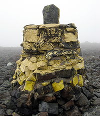
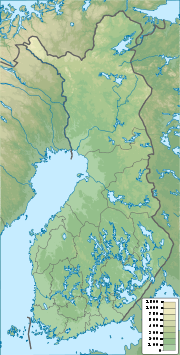
The summit of HaltiElevation 1,365 m (4,478 ft) Listing Country high point Location Location of Halti in Finland (on Norwegian border) Location Kåfjord,  Norway
Enontekiö, Finland
Range Scandinavian Mountains Coordinates 69°18′28″N 21°16′20″E / 69.30778°N 21.27222°ECoordinates: 69°18′28″N 21°16′20″E / 69.30778°N 21.27222°E Climbing Easiest route walk about 50 km (31 mi) from Kilpisjärvi in Finland or walk from Kåfjorddalen in Norway Halti (or Finnish: Haltiatunturi, Northern Sami: Háldi, Swedish: Haldefjäll) is the highest fell in Finland, at 1,324 m (4,344 ft) above sea level, and thus the highest point in the country. The Halti fell is located in the municipality of Enontekiö in the province of Lapland at the border between Finland and Norway. The summit of Halti at 1,365 m (4,478 ft) is actually in Norway and it is known as Ráisduattarháldi.[1]
Halti was dimensioned and mapped by Finnish Erkki Perä. The highest point in Finland is a spur of Ráisduattarháldi at 1,324 m (4,344 ft) known as Hálditšohkka at the border of Norway. The highest mountain, its peak being in Finland, is Ridnitšohkka, at 1,316 m (4,318 ft).
A 50 km (31 mi) trekking path leads from Saana, Kilpisjärvi to Halti.
References
- ^ Store norske leksikon. "Halti" (in Norwegian). http://www.snl.no/Halti. Retrieved 2010-04-04.
Wikimedia Foundation. 2010.

