- Rumbek
Infobox Settlement
official_name = Rumbek
other_name =
native_name =
nickname =
settlement_type =
motto =
imagesize = 300px
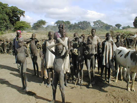
image_caption = A cattle farming camp in Rumbek
flag_size =
image_
seal_size =
image_shield =
shield_size =
image_blank_emblem =
blank_emblem_type =
blank_emblem_size =
mapsize =
map_caption =
mapsize1 =
map_caption1 =
image_dot_
dot_mapsize =
dot_map_caption =
dot_x = |dot_y =
pushpin_
pushpin_label_position =bottom
pushpin_map_caption =Location in Sudan
subdivision_type = Country
subdivision_name =
subdivision_type1 = State
subdivision_name1 = Lakes
subdivision_type2 =
subdivision_name2 =
subdivision_type3 =
subdivision_name3 =
subdivision_type4 =
subdivision_name4 =
government_footnotes =
government_type =
leader_title =
leader_name =
leader_title1 =
leader_name1 =
leader_title2 =
leader_name2 =
leader_title3 =
leader_name3 =
leader_title4 =
leader_name4 =
established_title =
established_date =
established_title2 =
established_date2 =
established_title3 =
established_date3 =
area_magnitude =
unit_pref =Imperial
area_footnotes =
area_total_km2 =
area_land_km2 =
area_water_km2 =
area_total_sq_mi =
area_land_sq_mi =
area_water_sq_mi =
area_water_percent =
area_urban_km2 =
area_urban_sq_mi =
area_metro_km2 =
area_metro_sq_mi =
area_blank1_title =
area_blank1_km2 =
area_blank1_sq_mi =
population_as_of =2005
population_footnotes =
population_note =
population_total =100,000 (est)
population_density_km2 =
population_density_sq_mi =
population_metro =
population_density_metro_km2 =
population_density_metro_sq_mi =
population_urban =
population_density_urban_km2 =
population_density_urban_sq_mi =
population_blank1_title =Ethnicities
population_blank1 =
population_blank2_title =Religions
population_blank2 =
population_density_blank1_km2 =
population_density_blank1_sq_mi =
timezone =
utc_offset =
timezone_DST =
utc_offset_DST =
latd=6|latm=48|lats= |latNS=N
longd=29 |longm=41 |longs= |longEW=E
elevation_footnotes =
elevation_m =
elevation_ft =
postal_code_type =
postal_code =
area_code =
blank_name =
blank_info =
blank1_name =
blank1_info =
website =
footnotes =Rumbek ( _ar. رمبك) is the
capital of the state of Lakes (also known as "Buhayrat") in southernSudan . Following the peace agreement ending theSecond Sudanese Civil War , theSudanese People's Liberation Movement chose it as the interim administrative center of the semi-autonomous southern regions. Juba became the permanent capital. Rumbek had a population of slightly under 100,000 in 2005, and sustained significant damage during the conflict.It is serviced by a dirt airstrip. There are some paved roads being built, both the airstrip and many of the roads being built by the main roads contractor
Civicon Ltd. . The city is the home of three tribes ofDinka : Aliab, Chic and Agar. Non-Dinka peoples, such asAtout andJurbel , also live in Rumbek.Fact|date=May 2007External links
* [http://news.bbc.co.uk/2/hi/africa/4192133.stm South Sudan's unlikely capital] ,
BBC ,21 January 2005
Wikimedia Foundation. 2010.

