- Wymbritseradiel
Infobox Settlement
official_name = Wymbritseradiel
other_name = Wymbritseradeel
mapsize = 280px
subdivision_type = Country
subdivision_name =Netherlands
subdivision_type1 = Province
subdivision_name1 =Friesland
area_footnotes = (2006)
area_total_km2 = 162.74
area_land_km2 = 138.33
area_water_km2 = 24.41
population_as_of =1 January ,2007
population_note = Source: CBS, [http://statline.cbs.nl/ Statline] .
settlement_type = Municipality
population_total = 16136
population_density_km2 = 117
timezone = CET
utc_offset = +1
timezone_DST = CEST
utc_offset_DST = +2
latd = 53
latm = 1
latNS = N
longd = 5
longm = 37
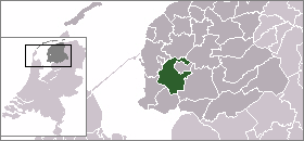
longEW = EWymbritseradiel is a
municipality in the northernNetherlands . Its official name is in West Frisian. The name in Dutch is Wymbritseradeel (Pronunciation|470 Wymbritseradeel.ogg).Population centres
Abbega ,Blauwhuis ,Folsgare ,Gaastmeer ,Gauw ,Goënga ,Greonterp ,Heeg ,Hommerts ,Idzega ,IJlst ,Indijk ,Jutrijp ,Koufurdurrige ,Nijland ,Oosthem ,Oppenhuizen ,Oudega ,Sandfirden ,Scharnegoutum ,Smallebrugge ,Tirns ,Tjalhuizum ,Uitwellingerga ,Westhem ,Wolsum ,Woudsend ,Ypecolsga .External links
* [http://www.wymbritseradiel.nl Official website]

Wikimedia Foundation. 2010.