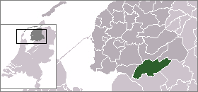
- Weststellingwerf
Infobox Settlement
official_name = Weststellingwerf
mapsize = 280px
subdivision_type = Country
subdivision_name =Netherlands
subdivision_type1 = Province
subdivision_name1 =Friesland
area_footnotes = (2006)
area_total_km2 = 228.36
area_land_km2 = 222.15
area_water_km2 = 6.20
population_as_of =1 January ,2008
population_note = Source: CBS, [http://statline.cbs.nl/ Statline] .
settlement_type = Municipality
population_total = 25679
population_density_km2 = 115
timezone = CET
utc_offset = +1
timezone_DST = CEST
utc_offset_DST = +2Weststellingwerf (Pronunciation|468 Weststellingwerf.ogg) is a
municipality in the province ofFriesland in the northernNetherlands .It is one of the municipalities of Friesland, where the spoken language is not West Frisian; instead,Stellingwerfs , a dialect ofDutch Low Saxon , is spoken here.Population centres
Blesdijke ,Boijl ,De Blesse ,De Hoeve ,Langelille ,Munnekeburen ,Nijeholtpade ,Nijeholtwolde ,Nijelamer ,Nijetrijne ,Noordwolde ,Oldeholtpade ,Oldeholtwolde ,Oldelamer ,Oldetrijne ,Oosterstreek ,Peperga , Scherpenzeel,Slijkenburg ,Sonnega ,Spanga ,Steggerda ,Ter Idzard ,Vinkega ,Wolvega ,Zandhuizen .Wolvega
Wolvega is the capital city of Weststellingwerf.
Peperga
Peperga is the birth place of the last governor of
New Amsterdam ,Peter Stuyvesant .External links
* [http://www.weststellingwerf.nl Official Website]

Wikimedia Foundation. 2010.