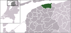
- Dongeradeel
-
Dongeradeel
Dongeradiel— Municipality — 
Flag
Coat of armsCoordinates: 53°19′N 6°0′E / 53.317°N 6°ECoordinates: 53°19′N 6°0′E / 53.317°N 6°E Country Netherlands Province Friesland Area(2006) - Total 266.94 km2 (103.1 sq mi) - Land 167.27 km2 (64.6 sq mi) - Water 99.67 km2 (38.5 sq mi) Population (1 January 2007) - Total 24,876 - Density 149/km2 (385.9/sq mi) Source: CBS, Statline. Time zone CET (UTC+1) - Summer (DST) CEST (UTC+2) Dongeradeel (
 pronunciation (help·info), West Frisian: Dongeradiel) is a municipality in the northern Netherlands.
History
Dongeradeel was created in 1984 from a merger of the old municipalities Westdongeradeel, Oostdongeradeel, and Dokkum. The new municipality is still colloquially referred to in the plural, "de Dongeradelen".
Population centres
Aalsum, Anjum, Bornwird, Brantgum, Dokkum, Ee, Engwierum, Foudgum, Hantum, Hantumeruitburen, Hantumhuizen, Hiaure, Holwerd, Jouswier, Lioessens, Metslawier, Moddergat, Morra, Nes, Niawier, Oosternijkerk, Oostrum, Paesens, Raard, Ternaard, Waaxens, Wetsens, Wierum.
External links
Achtkarspelen · Ameland · Boarnsterhim · Dantumadiel · Dongeradeel · Ferwerderadiel · Franekeradeel · Gaasterlân-Sleat · Harlingen · Heerenveen · Het Bildt · Kollumerland c.a. · Leeuwarden · Leeuwarderadeel · Lemsterland · Littenseradiel · Menaldumadeel · Ooststellingwerf · Opsterland · Schiermonnikoog · Skarsterlân · Smallingerland · Súdwest-Fryslân · Terschelling · Tytsjerksteradiel · Vlieland · Weststellingwerf ·

See also: Netherlands · Provinces · Municipalities Categories:- Municipalities of Friesland
- Friesland geography stubs
Wikimedia Foundation. 2010.

