- Ferwerderadiel
Infobox Settlement
official_name = Ferwerderadiel
image_
seal_size = 70px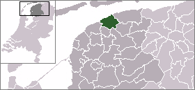
mapsize = 280px
subdivision_type = Country
subdivision_name =Netherlands
subdivision_type1 = Province
subdivision_name1 =Friesland
area_footnotes = (2006)
area_total_km2 = 133.18
area_land_km2 = 97.65
area_water_km2 = 35.53
population_as_of =1 January ,2007
population_note = Source: CBS, [http://statline.cbs.nl/ Statline] .
settlement_type = Municipality
population_total = 8898
population_density_km2 = 91
timezone = CET
utc_offset = +1
timezone_DST = CEST
utc_offset_DST = +2Ferwerderadiel (Pronunciation|446 Ferwerderadeel.ogg) is a
municipality in the northernNetherlands .Population centres
Bartlehiem ,Blije ,Burdaard ,Ferwert ,Ginnum ,Hallum ,Hegebeintum ,Jannum ,Jislum ,Lichtaard ,Marrum ,Reitsum ,Wânswert .External links
* [http://www.ferwerderadiel.nl Official Website]


Wikimedia Foundation. 2010.