Osterfjorden

Osterfjorden
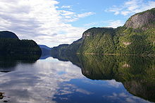
Indre Osterfjorden, north of Osterøy in Hordaland, Norway.

Osterfjorden is one of three fjords surrounding the island Osterøy.

The fiord runs between Lindås and Osterøy and is 27 km long, 1-3 km wide. The largest depth is 639 m.

It connects Sørfjorden in the south to Veafjorden in the east. Along Osterfjorden are the villages of Knarvik, Hjellvik, Eikanger, Hosanger, Fotlandsvåg, Tysse and Stamnes

Coordinates: 60°34′40″N 5°24′54″E / 60.5779°N 5.41489°E / 60.5779; 5.41489


Wikimedia Foundation. 2010.

Игры ⚽ Нужна курсовая?

Look at other dictionaries:

  • Osterøy — kommune   Municipality   …   Wikipedia

  • Nordhordland Bridge — Nordhordland Bridge …   Wikipedia

  • Hamre, Osterøy — Hamre is a former municipality in Hordaland county, Norway.The parish of Hammer was established as a municipality January 1, 1838 (see formannskapsdistrikt). The name was changed to Hamre in 1915.On January 1, 1904 the district Åsane was… …   Wikipedia

  • Stamneshella — (or Stamnes) is a village in Vaksdal municipality, Norway. It is located in inner Osterfjorden …   Wikipedia

  • Martial law in Trondheim in 1942 — v · …   Wikipedia

  • SS Oster — is a Norwegian steamship built in 1908 by Christianssands Mekaniske Værksted for the Indre Nordhordlandske Dampskibsselskab. It sailed between Bergen and Osterfjorden in Norway with passengers and goods from 1908 until World War II when it was… …   Wikipedia

  • Ola Raknes — Born 17 January 1887(1887 01 17) Bergen, Norway Died 28 January 1975(1975 01 28) …   Wikipedia

Share the article and excerpts

Direct link
Do a right-click on the link above
and select “Copy Link”