Dorrigo Plateau

Dorrigo Plateau
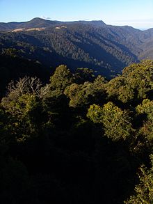
The plateau drops into steep valleys in the Dorrigo National Park.

Dorrigo Plateau is a plateau in northern New South Wales, which forms part of the Great Dividing Range. The plateau is sometimes referred to as the Dorrigo & Guy Fawkes Plateau.

The town of Dorrigo, 580 kilometres north of the Sydney and 60 kilometres from the coastal city of Coffs Harbour, is located on the eastern edge.

Richard Craig was the first European to discover the Plateau, following the traditional indigenous route to Armidale, New South Wales from the Grafton area. Using his skills as a horseman, Craig travelled along the western side of the Nymboida River. Craig's track became a road, now roughly following the same path as the present Grafton to Armidale Rd and travelling through the present day villages of Nymboida, Billy's Creek, Dundurrabin, Tyringham and Ebor (elevation 1300m).[1] Timbergetters followed Craig through the sub tropical rainforest and many sawmills grew due to demand for timber, initially the highly prized Australian Red Cedar (Toona australis).

Today, the main access road traversing the plateau from east to west is the Waterfall Way.

The Dorrigo Plateau and surrounding Guy Fawkes area was created by successive basaltic lava flows from the Ebor Volcano covering the original granite base. Weathering from high rainfall caused an escarpment to form as the more ancient rocks underneath remained intact.[2]

See also

References

  1. ^ "History of the Dorrigo Area". Dorrigo Chamber of Commerce. 2009. http://www.dorrigo.com/community/about-the-dorrigo-plateau/135-history-of-the-dorrigo-area.html. Retrieved 1 August 2011. 
  2. ^ Dorrigo National Park:World Heritage Area Information brochure. 1998. New South Wales National Parks and Wildlife Service.


Wikimedia Foundation. 2010.

Игры ⚽ Поможем решить контрольную работу

Look at other dictionaries:

  • Dorrigo, New South Wales — Dorrigo New South Wales Dorrigo Main Square …   Wikipedia

  • Dorrigo — is a place in New South Wales, Australia; it may refer to: Dorrigo Plateau, Northern Tablelands of NSW Dorrigo, New South Wales, town on the Dorrigo Plateau Dorrigo National Park, on the Dorrigo Plateau Dorrigo railway line, largely defunct… …   Wikipedia

  • Dorrigo daisy — /dɒrigoʊ ˈdeɪzi/ (say doreegoh dayzee) noun a rare plant, Olearia flocktoniae, with white daisy like flowers, found only around the Dorrigo plateau in disturbed margins of rainforest and wet sclerophyll forest. Also, Dorrigo daisy bush …  

  • Dorrigo — la grand place de Dorrigo Administration Pays …   Wikipédia en Français

  • Dorrigo railway line — Ulong railway station The Dorrigo railway line is a closed railway line in the north of New South Wales, Australia. It branches from the North Coast line at Glenreagh.[1] Contents …   Wikipedia

  • Escarpment — In geomorphology, an escarpment is a transition zone between different physiogeographic provinces that involves a sharp, steep elevation differential, characterized by a cliff or steep slope. Escarpment is generally used interchangeably with… …   Wikipedia

  • Norman Jolly — Personal information Batting style unknown Bowling style N/A (wicket keeper) International information National side Australian Career statistics Competition First class …   Wikipedia

  • Tisiphone abeona — Scientific classification …   Wikipedia

  • Contenu:Australie — Projet:Australie/Liste des articles Liste mise à jour régulièrement par MyBot (d · c · b) à partir des articles liés au bandeau {{Portail Australie}} Modifications récentes des articles ayant le bandeau de ce portail… …   Wikipédia en Français

  • New England (Australia) — Infobox Australian Place | type = region name = New England state = nsw caption = Mt Duval in the New England lga = pop = 175,883 cite web url = http://www.business.nsw.gov.au/region/profiles/newengland northwest.htm title = Department of State… …   Wikipedia

Share the article and excerpts

Direct link
Do a right-click on the link above
and select “Copy Link”