- Cherhill
-
Cherhill is a village in Wiltshire, England located on the A4 road between Calne and Marlborough and about 87 miles (140 km) west of London.
Contents
Overview
Cherhill is known for the Cherhill White Horse cut into the chalk hillside in 1780, the Landsdowne obelisk on the Cherhill Downs, and the crop circles that appeared in the fields at the bottom of the Downs. The area around the horse and obelisk is owned by the National Trust.
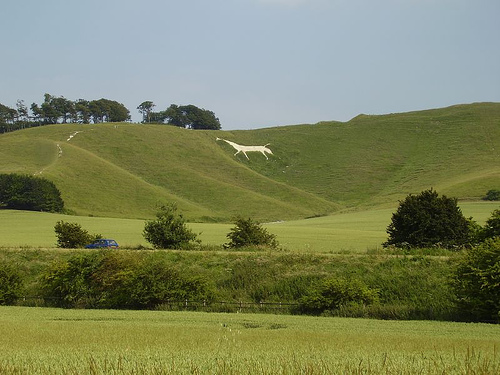
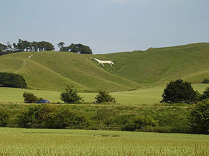 Cherhill White Horse seen from the village
On a clear day the 840 ft (260 m) summit offers fine views, up to 25 miles (with the water tower at Tetbury in Gloucestershire visible). Atop the tall hill to the north of the village, opposite to Cherhill downs; it is said to be possible to see the Severn crossings to South Wales, 38 miles (61 km) to the west.
History
John Marius Wilson's Imperial Gazetteer of England and Wales (1870-1872) says of Cherhill:[1]
“ CHERHILL, a parish in Calne district, Wilts; near Wans Dyke, 2½ miles E by S of Calne r. station, and 7 NNE of Devizes. It has a post office under Chippenham. Acres, 1, 817. Real property, £2, 574. Pop., 364. Houses, 88. The property is all in one estate. An ancient square camp with double works, called Oldbury, is on the summit of a chalk hill; and the figure of a horse, 157 feet long, cut out of the turf about 1780, and visible for many miles, is on the side of the same hill. The living is a rectory in the diocese of Salisbury. Value, £300. Patron, the Bishop of Salisbury. The church is old but very good; and there is a Primitive Methodist chapel. ” Near the village is the Lansdowne Monument, or Cherhill Monument, a 125-foot stone obelisk erected in 1845 by the Third Marquis of Lansdowne in honour of his ancestor Sir William Petty.[2]
Population and community
Cherhill has a population of around 900 people with a mixture of housing ranging from thatched cottages (some ranging back to the 14th Century) to newly built detached houses. It has a church, school, pub, village hall and cricket team. The local community spirit is typical of a close-knit village community. Cherhill parish forms part of The Oldbury Benefice together with Compton Bassett, Yatesbury, Heddington and Calstone Wellington.
Access
Cherhill lies upon the old coaching road, the A4; which runs from central London to Bristol. The nearest railway station is Chippenham, on the GWR line (with direct services to London Paddington & Bristol Temple Meads) 9 miles (14 km) to the east. The nearest motorway junction is junction 17 of the M4 north of Chippenham, 15 miles (24 km) away from Cherhill. The village is served by the Wigglybus scheme, which runs to Cherhill and other surrounding villages, into nearby Calne and further transport links.
Governance
Cherhill is located in the Wiltshire North parliamentary constituency and governed by Cherhill Parish Council and the Wiltshire Council unitary authority, which is responsible for all significant local government functions.[3]
The Cherhill Gang
The Cherhill Gang were a notorious group of highway men who operated in the 18th century on the London to Bath main road (A4) which passes through the village — they were noted for their robbery technique of attacking carriages of the wealthy Londoners whilst completely naked to shock the passengers into handing over their money and importantly so that they could not be identified. A painting depicting one such attack can be seen in the Black Horse pub, on the A4 main road in the village.
Cherhill White Horse and Oldbury Hill Fort
The Cherhill White horse was cut out of the hillside in 1780. Due to chalk being washed away and weeds growing on it, it has been restored several times. The horse is visible from miles around, and has become a landmark synonymous with the village and local area. The most recent restoration to the delicate chalk carving took place in 2006.
In 2005 the horse was covered in black stripes to give it more of an exotic appearance, the owners of a local car franchise were attempting to make it appear more like a Panda (although it more closely resembled a Zebra), as a publicity stunt to help launch a new vehicle of the same name.
The top of the National Trust owned Cherhill Downs is home to the neolithic settlement, Oldbury Hill Fort. From here it is possible to see the route of an ancient Roman road heading towards the nearby Wansdyke trade route. The top of the hill is popular with ramblers, dog walkers and power kiters, owing to the powerful winds in action.
Bibliography
- Plenderleath, Rev. W. C., On the White Horses of Wiltshire and Its Neighbourhood (Wilts Archaeological Magazine, vol. 14 for the year 1872, pp. 12-30)
- Plenderleath, Rev. W. C., White Horses of the West of England (London, Allen & Storr, 1892)
- Plenderleath, Rev. W. C., Plenderleath’s Memoranda of Cherhill (2001)[4]
Notes
- ^ Descriptive Gazetteer entry for CHERHILL at visionofbritain.org.uk, accessed 20 July 2008
- ^ The Lansdowne Monument at geograph.org.uk, accessed 24 April 2010
- ^ [1]
- ^ Hobnob Marketplace at Hobnob Press (Other Publications), accessed 19 July 2008
See also
External links
Categories:- Villages in Wiltshire
Wikimedia Foundation. 2010.