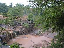
Namtok Kaeng Song

Namtok Kaeng Song
Kaeng Song Waterfall
BestKaengSongWaterfall.JPG
Location Wang Thong district, Phitsanulok Province, Thailand
Coordinates 16°51′59″N 100°37′56″E / 16.86639°N 100.63222°E / 16.86639; 100.63222
Watercourse Wang Thong River

Namtok Kaeng Song (Thai: น้ำตกแก่งซอง) is a waterfall and tourist attraction in the Wang Thong district of Phitsanulok Province in Thailand. This waterfall is situated on the Wang Thong River off Lomsak Road (Highway 12) at kilometer 45. The falls have small pavilions to accommodate tourists, and concessions are sold on the premises. Tire tubes are also available for swimming in the river near the falls.

Events

In June, 2005, Phitsanulok Province initiated a campaign entitled "Sip Coffee at Kaeng Song, Paddle Along Nam Khek Rapids," and held the first Kaeng Song Coffee Tasting Festival to celebrate the opening of the rafting season as well as to promote a regional specialty, coffee. The next such festival was held from July 7 through the end of October, 2006. This year the festival is being held from July 1, 2007 through October 31, 2007 under the name "Kaeng Song Cafe - Khek river rafting festival."

Gallery

External references


Wikimedia Foundation. 2010.

Игры ⚽ Поможем написать курсовую

Look at other dictionaries:

  • Kaeng Khoi — แก่งคอย Provinz: Saraburi Fläche: 801,1 km² Einwohner: 88.921 (2005) Bev.dichte: 1111,0 E./km² PLZ: 18110 …   Deutsch Wikipedia

  • Amphoe Kaeng Khoi — Kaeng Khoi แก่งคอย Provinz: Saraburi Fläche: 801,1 km² Einwohner: 88.921 (2005) Bev.dichte: 1111,0 E./km² PLZ: 18110 …   Deutsch Wikipedia

  • Nationalpark Namtok Yong — Nationalpark Namtok Yong …   Deutsch Wikipedia

  • Amphoe Wang Thong — Wang Thong วังทอง Provinz: Phitsanulok Fläche: 1.687,05 km² Einwohner: 120.575 (2005) Bev.dichte: 72 E./km² PLZ: 65130 …   Deutsch Wikipedia

  • Wang Thong — วังทอง Provinz: Phitsanulok Fläche: 1.687,05 km² Einwohner: 120.575 (2005) Bev.dichte: 72 E./km² PLZ: 65130 …   Deutsch Wikipedia

  • List of Thailand-related articles — Thailand, known officially as the Kingdom of Thailand (IPAEng|ˈtaɪlænd, th. ราชอาณาจักรไทย, IPA2|râːtɕʰa ʔaːnaːtɕɑ #x0300;k tʰɑj) is a country in Southeast Asia. To its east lie Laos and Cambodia; to its south, the Gulf of Thailand and Malaysia;… …   Wikipedia

  • Liste de chutes d'eau — Cette liste est incomplète ou mal ordonnée. Votre aide est la bienvenue ! Salto Angel, la plus haute chute du monde, Venezuela Ceci est une liste des chutes d ea …   Wikipédia en Français

  • Ubon Ratchathani Province — Infobox Thai Province name = Ubon Ratchathani thai = อุบลราชธานี capital = Ubon Ratchathani area = 15,744.8 arearank = 5th population = 1,691,441 population as of = 2000 populationrank = 4th density = 107 densityrank = 44th isocode = TH 34… …   Wikipedia

  • Phitsanulok Province — Infobox Thai Province name = Phitsanulok thai = พิษณุโลก capital = Phitsanulok area = 10,815.8 arearank = 16th population = 792,678 population as of = 2000 populationrank = 27th density = 73 densityrank = 60th isocode = TH 65 governor = Sombun… …   Wikipedia

  • Nationalparks in Thailand — Chattrakan Nationalpark, Phitsanulok Nationalparks in Thailand werden von der thailändischen Forstverwaltung, dem Royal Forest Department, verwaltet. Im Jahr 2006 gab es insgesamt 148 entsprechend geschützte Gebiete mit einer Gesamtfläche von… …   Deutsch Wikipedia

Share the article and excerpts

Direct link
Do a right-click on the link above
and select “Copy Link”