- Todra Gorge
-
Todra Gorge 
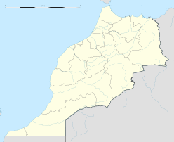
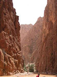
View from the canyon floorMorocco Floor elevation approx. 1,500 metres (4,921 ft) Long-axis length 15 miles (24 km) Width 10 to 1,000 metres (33 to 3,300 ft) Coordinates 31°33′N 5°33′W / 31.55°N 5.55°WCoordinates: 31°33′N 5°33′W / 31.55°N 5.55°W Todra Gorge (French: Gorges de Todra, Arabic: تدرة جورج) is a canyon in the eastern part of the High Atlas Mountains in Morocco, near the town of Tinerhir. Both the Todra and neighbouring Dades Rivers have carved out cliff-sided canyons (Arabic: wadi) on their final 40 kilometres (25 mi) through the mountains. The last 600 metres (1,969 ft) of the Todra gorge are the most spectacular. Here the canyon narrows to a flat stony track, in places as little as 10 metres (33 ft) wide, with sheer and smooth rock walls up to 160 metres (525 ft) high on each side.
The tiny glacier stream is something of a misfit, the river which once filled the gorge must have carried a lot more water. It is easy to hike in the gorge along a well-maintained paved road. The scenery is spectacular. Local people live in the area and can be seen with their small donkeys or herding camels and goats.
The area is no longer as remote as it once was. A well-maintained asphalt road leads up the valley from Tinerhir to the gorge. A concrete road continues up the valley, past the hotels at the mouth of the gorge all the way to the villages of Aït Hani, Tamtatouchte, and Imilchil.
Thanks to its robust rock sides with many uneven surfaces, Todra Gorge is popular among rock climbers. More than 150 routes rated French Grade 5+ to 8 have been bolted in the canyon.
The Todra Gorge was featured on the premiere of the United States reality show Expedition Impossible.
External links
Categories:- Canyons and gorges of Morocco
- Morocco geography stubs
Wikimedia Foundation. 2010.


