- Kentucky Bend
-
Coordinates: 36°31′46″N 89°30′13″W / 36.529502°N 89.503555°W
The Kentucky Bend, variously called the New Madrid Bend, Madrid Bend, Bessie Bend, or Bubbleland,[1] is an exclave of Fulton County, Kentucky, in the United States.
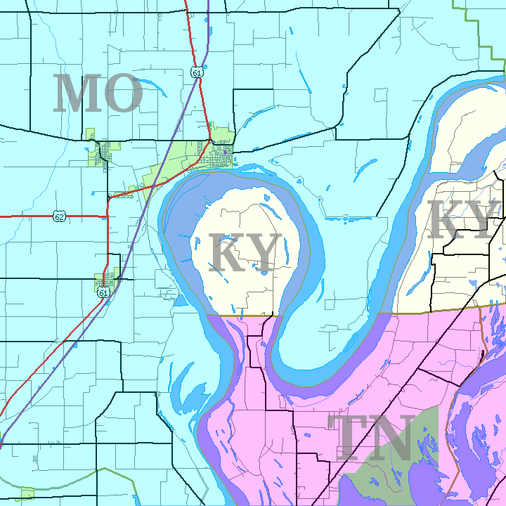
Kentucky Bend is a piece of land on the inside of an oxbow loop meander of the Mississippi River. It is completely surrounded by the states of Tennessee and Missouri. Because it is surrounded by two (rather than one) 'foreign' states, Kentucky bend is not (as it is sometimes called) an enclave.
Kentucky Bend is the extreme southwestern corner of Kentucky. As of the 2000 census the population was 17 persons in this area, officially known by the United States Census Bureau as Fulton County West Census County Division (CCD), a subdivision of Fulton County. The peninsula includes the lowest point in the state of Kentucky, at the banks of the Mississippi River. The only highway into the area is Tennessee State Route 22, whose continuation into Kentucky Bend at one time was signed as Kentucky State Route 313.
The mailing address of the area is Tiptonville, Tennessee.
Contents
Geography
The Kentucky Bend covers a land area of 45.472 km2 (17.557 sq mi), according to the Census Bureau.[2] Surveyors marking the boundary between Kentucky and Tennessee had only estimated where their line would meet the Mississippi; later, more detailed surveys revealed the location of this line to pass through north-south bends in the river, creating a division of the peninsula.[3] The western border of Kentucky is designated as the Mississippi River, as is the eastern border of Missouri—thus the creation of a "notch" for Kentucky, but not for Tennessee.
History
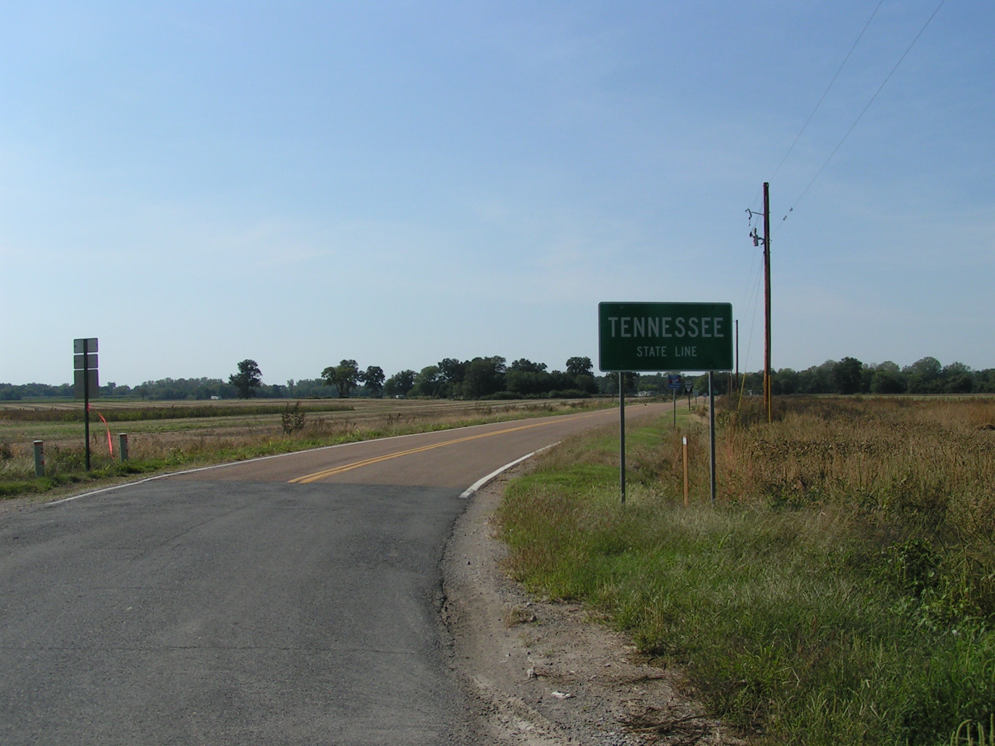
 State line between the Kentucky Bend and Route 22 in Tennessee.
The state of Tennessee contested the inclusion of the Kentucky Bend in the state of Kentucky, and it was legally part of Obion County, Tennessee, until at least 1848,[4] but Tennessee eventually dropped its claim.
In 1812, this area of the river was highly disrupted and was reported to even flow backwards because of the 1811–1812 New Madrid series of earthquakes, some of the largest ever felt in the United States.[5]
Due to its extremely fertile soil, Kentucky Bend was once a major cotton-producing area. The 1870 census found more than 300 residents. In The West Tennessee Farm edited by Marvin Downing (University of Tennessee at Martin Press, 1979), Norman L. Parks reports that in 1880 there was a population of 303, of whom 18 were African American. By 1900, there were "large numbers of Negroes in the Bend" to plant and harvest the cotton.
This area of the Mississippi River, from just east at "Island Number Ten" around to the town of New Madrid, Missouri, was the site of a Civil War battle from February 28 to April 8, 1862, the Battle of Island Number Ten.
In Mark Twain's book Life on the Mississippi,[6] he reports on the six-decade long feud between the Darnell and Watson families and other elements of life in the Bend. "In no part of the South has the vendetta flourished more briskly, or held out longer between warring families, than in this particular region,” he wrote. Twain continues:
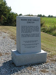 Front stone for the Madrid Bend families' cemetery (known in official registries as Whitson Cemetery).Both families belonged to the same church ... They lived each side of the line, and the church was at a landing called Compromise. Half the church and half the aisle was in Kentucky, the other half in Tennessee. Sundays you'd see the families drive up, all in their Sunday clothes, men, women, and children, and file up the aisle, and set down, quiet and orderly, one lot on the Tennessee side of the church and the other on the Kentucky side; and the men and boys would lean their guns up against the wall, handy, and then all hands would join in with the prayer and praise; though they say the man next to the aisle didn't kneel down, along with the rest of the family; kind of stood guard.
References
- ^ Suhr, Jim (2002-08-04). "Living 'round the bend". Columbia Daily Tribune. http://archive.showmenews.com/2002/Aug/20020804Feat006.asp. Retrieved 2007-01-15.
- ^ Detailed Tables, Census Bureau (2000), accessdate=2008-07-04
- ^ "Life on the Mississippi". Kentucky Educational Television. http://www.ket.org/kentuckylife/800s/kylife804.html. Retrieved 2007-01-15.
- ^ "Descendants of James Taylor Foster (1848-1920)". 1997-12-21. http://members.lwol.com/usna/Genealogy/jtfoster.html. Retrieved 2007-01-15.
- ^ http://www.worldatlas.com/aatlas/infopage/kybend.htm
- ^ Twain, Mark (2004-07-09). "Life on the Mississippi, Part 6". Project Gutenberg. http://www.gutenberg.org/files/8476/8476-h/8476-h.htm. Retrieved 2007-01-15.
External links
Categories:- Border irregularities of the United States
- Exclaves in Kentucky
- Geography of Fulton County, Kentucky
- Geography of Kentucky
- Mississippi River
- Geography of Obion County, Tennessee
- Unincorporated communities in Kentucky
- Borders of Kentucky
- Populated places in Fulton County, Kentucky

Wikimedia Foundation. 2010.