- Hampton, Maryland
Infobox Settlement
official_name = Hampton, Maryland
settlement_type = CDP
nickname =
motto =
imagesize =
image_caption =
image_
imagesize =
image_caption =
image_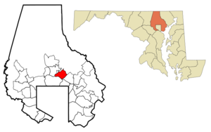
mapsize = 250x200px
map_caption = Location of Hampton, Maryland
mapsize1 =
map_caption1 =subdivision_type = Country
subdivision_name =United States
subdivision_type1 = State
subdivision_name1 =Maryland
subdivision_type2 = County
subdivision_name2 = Baltimore
government_footnotes =
government_type =
leader_title =
leader_name =
leader_title1 =
leader_name1 =
established_title =
established_date =unit_pref = Imperial
area_footnotes =
area_magnitude =
area_total_km2 = 14.8
area_land_km2 = 14.8
area_water_km2 = 0.0
area_total_sq_mi = 5.7
area_land_sq_mi = 5.7
area_water_sq_mi = 0.0population_as_of = 2000
population_footnotes =
population_total = 5004
population_density_km2 = 338.3
population_density_sq_mi = 876.2timezone = Eastern (EST)
utc_offset = -5
timezone_DST = EDT
utc_offset_DST = -4
elevation_footnotes =
elevation_m = 103
elevation_ft = 338
latd = 39 |latm = 25 |lats = 0 |latNS = N
longd = 76 |longm = 34 |longs = 59 |longEW = Wpostal_code_type =
postal_code =
area_code =
blank_name = FIPS code
blank_info = 24-36512
blank1_name = GNIS feature ID
blank1_info = 0590409
website =
footnotes =Hampton is an
unincorporated community and acensus-designated place inBaltimore County, Maryland . The population was 5,004 at the 2000 census. Hampton is often considered a subdivision of the nearby community of Towson and is located just north ofBaltimore City ,Maryland , about twenty minutes from downtown Baltimore. Hampton contains 635 residences situated on lots up to several acres in a park-like setting. The community is anchored by its principle landmark, theHampton National Historic Site . The homes in the Hampton community range quite widely in price, design, features and lot sizes. TheTowson United Methodist Church is located in Hampton, flanked on the south by I-695 andGoucher College .History
In 1929 the Hampton Development Company was formed and the land around the Hampton Mansion site was subdivided, creating the Hampton Community. The Hampton Mansion remained in the Ridgely family until it became a
National Park in 1948. [cite book|author=Ann Milkovich McKee|title=Images of America — Hampton National Historic Site|publisher=Charleston, SC: Arcadia Publishing|date=2007|isbn=978-0-7385-4418-2]Geography
Hampton is located at coor dms|39|24|60|N|76|34|59|W|city (39.416656, -76.583027)GR|1.
According to the
United States Census Bureau , the CDP has a total area of 5.7 square miles (14.8 km²), all of it land.Demographics
As of the
census GR|2 of 2000, there were 5,004 people, 1,900 households, and 1,578 families residing in the CDP. Thepopulation density was 876.2 people per square mile (338.4/km²). There were 1,935 housing units at an average density of 338.8/sq mi (130.8/km²). The racial makeup of the CDP was 91.41% White, 1.48% African American, 6.00% Asian, 0.02% Pacific Islander, 0.22% from other races, and 0.88% from two or more races. Hispanic or Latino of any race were 1.48% of the population.There were 1,900 households out of which 29.1% had children under the age of 18 living with them, 75.3% were married couples living together, 5.7% had a female householder with no husband present, and 16.9% were non-families. 14.3% of all households were made up of individuals and 8.8% had someone living alone who was 65 years of age or older. The average household size was 2.62 and the average family size was 2.89.
In the CDP the population was spread out with 21.9% under the age of 18, 4.1% from 18 to 24, 19.3% from 25 to 44, 30.1% from 45 to 64, and 24.5% who were 65 years of age or older. The median age was 48 years. For every 100 females there were 94.2 males. For every 100 females age 18 and over, there were 91.5 males.
The median income for a household in the CDP was $95,546, and the median income for a family was $100,240. Males had a median income of $75,518 versus $42,479 for females. The
per capita income for the CDP was $43,850. About 0.4% of families and 1.8% of the population were below thepoverty line , including 1.3% of those under age 18 and 2.6% of those age 65 or over.Recent developments
The
Towson United Methodist Church announced plans in 2008 to sell convert|5|acre|ha of undeveloped, wooded property it owns on Hampton Lane to a developer, who plans to construct a senior housing complex there.cite news |author=Laura Barnhardt |title=Hampton residents fight development |publisher="The Baltimore Sun" |date=2008-02-18 |url=http://www.baltimoresun.com/news/local/baltimore_county/bal-md.co.hampton18feb18,0,5243251.story |accessdate=2008-02-19 ] A zoning change application has been submitted to Baltimore County officials to allow 16 residential units per acre (current zoning limits density to two residential units per acre). The president of the Hampton Improvement Association, representing neighborhood residents, said his group is "focused on the zoning issues and what that could do to the character of Hampton", saying they "oppose zoning changes that would allow higher density residential development and require trees to be knocked down". A spokesman for The Shelter Group, the developer, said they are cognizant of the neighbors' concerns and "look forward to coming up with a resolution that will work for everyone". The church's senior pastor, Rev. David Cooney, told the "Baltimore Sun", "We entered into this with Shelter, believing this is a good use for the land — that this is a good company and a needed service". The County Council will rule on the zoning change, after planning staff evaluation and public hearings, in September 2008.References
External links
* [http://www.hamptonmd.org/ Hampton Improvement Association]
Wikimedia Foundation. 2010.