- Korčula (town)
Infobox Settlement
official_name = Korčula
native and official name until 1918
nickname =
settlement_type =
motto =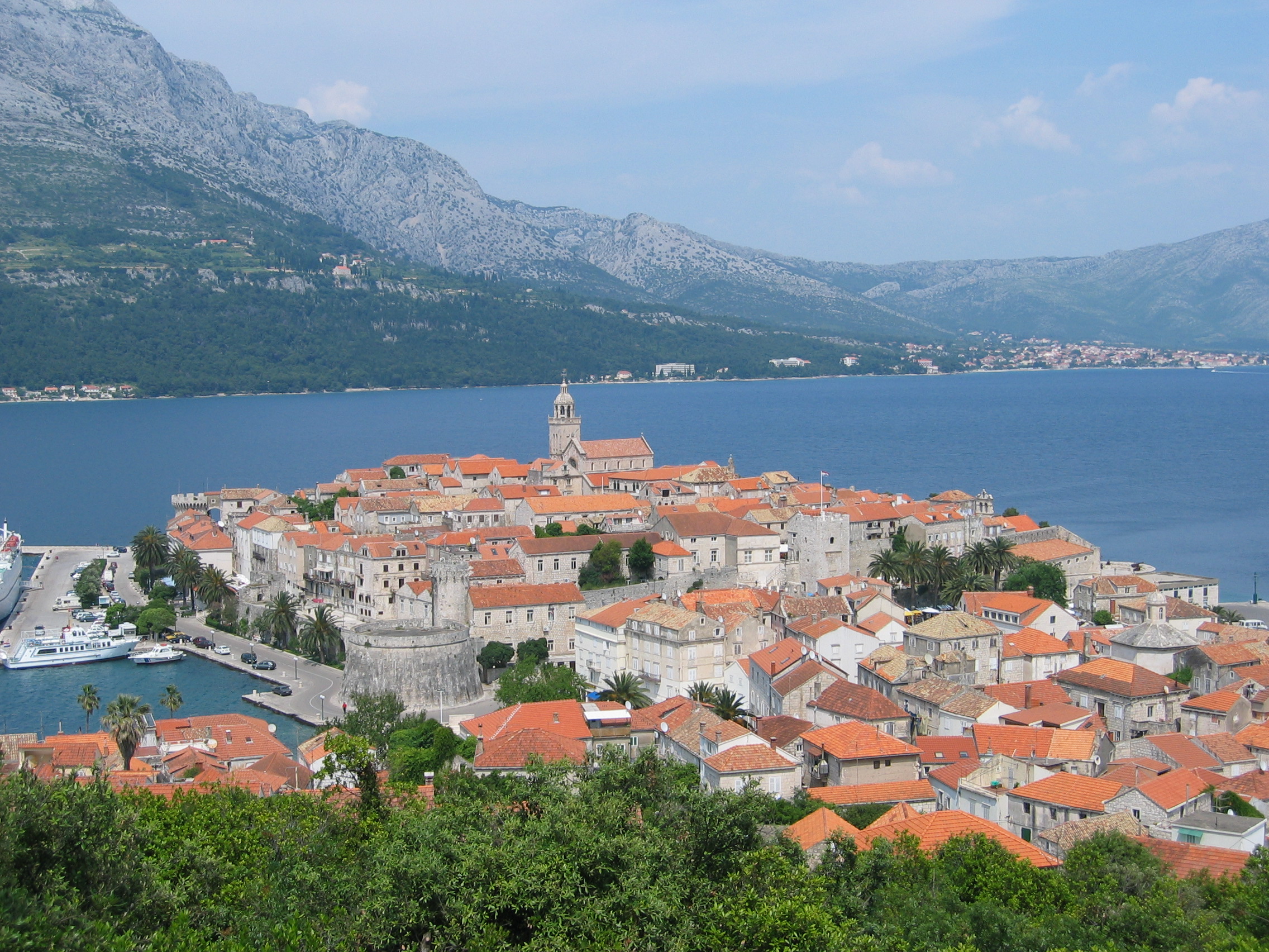
imagesize =
image_caption = Old Town
flag_size =
image_
seal_size =
image_shield =
shield_size = 80px
city_logo =
citylogo_size =
mapsize =
map_caption =
mapsize1 =
map_caption1 =
image_dot_
dot_mapsize =
dot_map_caption =
dot_x = |dot_y =
pushpin_
pushpin_label_position =
pushpin_map_caption = The location of Korčula within Croatia
pushpin_mapsize =
subdivision_type = Country
subdivision_name =Croatia
subdivision_type1 = County
subdivision_name1 =Dubrovnik-Neretva county
subdivision_type2 = Island
subdivision_name2 =Korčula
government_footnotes =
government_type =
leader_title = Mayor
leader_name = Mirko Duhović (SDP )
established_title =
established_date =
established_title2 =
established_date2 =
established_title3 =
established_date3 =
area_magnitude =
unit_pref =
area_footnotes =
area_total_km2 =
area_land_km2 =
area_water_km2 =
area_total_sq_mi =
area_land_sq_mi =
area_water_sq_mi =
area_water_percent =
area_urban_km2 =
area_urban_sq_mi =
area_metro_km2 =
area_metro_sq_mi =
population_as_of = 2001
population_footnotes =
population_note =
population_total = 5889
population_density_km2 =
population_density_sq_mi =
population_metro =
population_density_metro_km2 =
population_density_metro_sq_mi =
population_urban =
population_density_urban_km2 =
population_density_urban_sq_mi =
timezone = CET
utc_offset = +1
timezone_DST = CEST
utc_offset_DST = +2
latd=42 |latm=57 |lats= |latNS=N
longd=17 |longm=07 |longs=30 |longEW=E
elevation_footnotes =
elevation_m =
elevation_ft =
postal_code_type = Postal code
postal_code = 20260
area_code = 020
blank_name = Licence plate
blank_info = DU
blank1_name =
blank1_info =
website = [http://www.korcula.hr korcula.hr]
footnotes =Korčula ( _it. Curzola) is an ancient fortified town on the protected east coast of the
island ofKorčula , population 3,232 (2001), geographically located at 42°57′N, 17°07′E.The walled old city, with streets arranged in a herringbone pattern allowing free circulation of air but protecting against strong winds, is tightly built on a promontory that guards the narrow sound between the island and the mainland. Building outside the walls was forbidden until the 18th century, and the wooden drawbridge was only replaced in 1863. All of Korčula's narrow streets are stepped with the notable exception of the street running alongside the southeastern wall, called the Street of Thoughts as one did not have to worry about the steps. The town includes several interesting historic sights: the central
Romanesque-Gothic Cathedral of St Mark (built from 1301 to 1806), the 15th-century Franciscan monastery with its beautiful Venetian Gothiccloister , the civic council chambers, the palace of the former Venetian governors, grand 15th and 16th century palaces of the local merchant nobles, and the massive city fortifications.The devout
Catholic inhabitants of Korčula keep alive old folk church ceremonies and a war dance (moreška, maresca), once (in the middle ages) performed all over the Mediterranean.The city is notable for its Statute dating back to
1214 which prohibitedslavery , making Korčula the first place in the world to outlaw the practice.Korčula, like other islands and many coastal cities in
Dalmatia , also displays a dual Latin-Slav culture which developed from the late Roman era to the emergence of the modernCroatia n state. The island therefore possesses a distinctAdriatic orMediterranean cultural personality which sets it apart from the mountainous Dalmatian hinterland and continental Croatia further north.Gallery
External links
*http://www.korcula.net/ hr iconen icon
*http://www.ikorcula.net/ hr icon
*http://www.korcula.hr/ hr iconen iconen icon
*http://www.ikorculainfo.com/hr/ hr iconen iconen icon it icon cs icon pl icon sl icon
*http://www.korculainfo.com/ en iconde iconfr iconit icones iconpt icon
*http://www.croaziainfo.it/Korcula.html it icon

Wikimedia Foundation. 2010.