- Indiana State Road 110
Infobox road
state=IN
type=IN
route=110
alternate_name=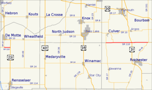
length_mi=
length_round=
length_ref=
established=
direction_a=
starting_terminus=
direction_b=
ending_terminus=
counties=Fulton, Jasper, Marshall
previous_type=IN
previous_route=109
next_type=IN
next_route=111State Road 110 in
Northern Indiana consists of two discontinuous east-west segments. Neither segment passes through any towns. The western portion is convert|2.5|mi|km long and connects State Road 10 withU.S. Route 231 in Jasper County. The eastern portion runs along the border between Fulton County and Marshall County; it is convert|16.4|mi|km long and connects State Road 17 at the west end with State Road 25 at the east end, and has an interchange withU.S. Route 31 south of Argos.Major intersections
Source: INDOT Roadway Referencing System [cite web|url=http://www.in.gov/indot/3361.htm|title=INDOT Roadway Referencing System] INint
county=Jasper
mile=0.00
road=
location=Jasper County
notes=SR 110 beginsINint
county=Marshall
cspan=4
mile=2.54
location=Marshall County
lspan=4
road=INint
mile=5.39
road=INint
mile=12.55
road=INint
mile=18.90
road=
notes=SR 110 endsReferences
External links
* [http://illi-indi.com/EndsPage.php?id=1110§ion=1 Indiana Highway Ends - SR 110]

Wikimedia Foundation. 2010.