Colo Parish, Camden

Colo Parish, Camden

Infobox Australian cadastral
name = Colo Parish
state = New South Wales


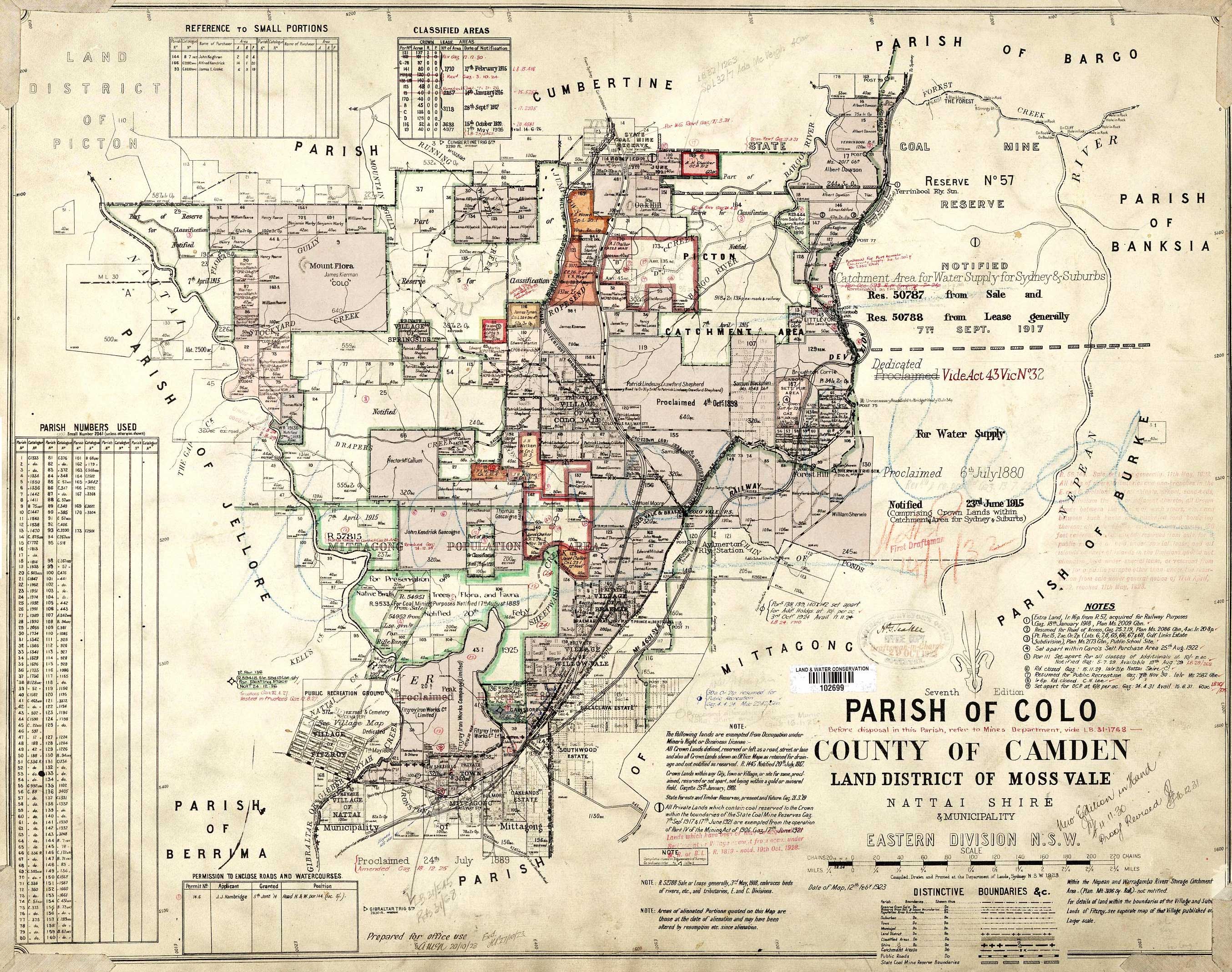
caption = 1923 parish map
county = Camden
land district = Moss Vale
division = Eastern
lga = Wingecarribee
region = Southern Highlands
est =
area =
near-nw = Jellore
near-n = Cumbertine
near-ne = Bargo
near-e = Banksia
near-se = Burke
near-s = Mittagong
near-sw = Berrima
near-w = Jellore

The Parish of Colo is a parish of the County of Camden in the Southern Highlands region of New South Wales. It is centred around the town of Colo Vale, and includes Aylmerton, Willow Vale, Alpine and Yerrinbool. It also includes the northern parts of Mittagong that are north of the Old Hume Highway. The new Hume Highway runs through the parish from south-west to north-east.

Its western boundary is the Nattai River and part of Gibbergunyah (Gibraltar) creek. The southern boundary for a large portion is the Old Hume Highway. The northern boundary is near, but not including Hill Top. The eastern boundary is the Nepean River. Part of the boundary in the north-east is Forest Creek and the Bargo River.

The Picton Loop railway line runs through the parish from north to south, including the station at Colo Vale. The Southern Highlands section of the Main Southern railway line also passes through the parish, including Yerrinbool station.

References

External links

* [http://www.gnb.nsw.gov.au/name_search/extract?id=JPIOwpsESX Geographic Names Board of New South Wales]
* [http://nla.gov.au/anbd.bib-an000040435117 Parish of Colo, County of Camden]


Wikimedia Foundation. 2010.

Игры ⚽ Нужно сделать НИР?

Look at other dictionaries:

  • Colo Parish — New South Wales 1923 parish map Region: Southern Highlands County: Camden …   Wikipedia

  • Mittagong Parish, Camden — Infobox Australian cadastral name = Mittagong Parish state = New South Wales caption = county = Camden land district = Moss Vale division = Eastern lga = Wingecarribee region = Southern Highlands est = area = near nw = Jellore near n = Colo near… …   Wikipedia

  • Berrima Parish, Camden — Infobox Australian cadastral name = Berrima Parish state = New South Wales caption = county = Camden land district = Moss Vale division = Eastern lga = Wingecarribee region = Southern Highlands est = area = near nw = Joadja near n = Jellore near… …   Wikipedia

  • Bargo Parish, Camden — Infobox Australian cadastral name = Bargo Parish state = New South Wales caption = county = Camden land district = Picton division = Eastern lga = Wollondilly, Wingecarribee est = area = near nw = Couridjah near n = Couridjah near ne = Wilton… …   Wikipedia

  • Mittagong Parish — New South Wales Region: Southern Highlands County: Camden Land District: Moss Vale Division: Eastern LGA …   Wikipedia

  • Cook County, New South Wales — Map of all coordinates from Google Map of all coordinates from Bing Export all coordinates as KML …   Wikipedia

  • performing arts — arts or skills that require public performance, as acting, singing, or dancing. [1945 50] * * * ▪ 2009 Introduction Music Classical.       The last vestiges of the Cold War seemed to thaw for a moment on Feb. 26, 2008, when the unfamiliar strains …   Universalium

  • United States — a republic in the N Western Hemisphere comprising 48 conterminous states, the District of Columbia, and Alaska in North America, and Hawaii in the N Pacific. 267,954,767; conterminous United States, 3,022,387 sq. mi. (7,827,982 sq. km); with… …   Universalium

  • List of smoking bans in the United States — Map of current and scheduled future statewide smoking bans as of 18 June 2011 (2011 06 18)[update] …   Wikipedia

  • Moss Vale, New South Wales — Moss Vale New South Wales …   Wikipedia

Share the article and excerpts

Direct link
Do a right-click on the link above
and select “Copy Link”