- Cadair Berwyn
-
Cadair Berwyn 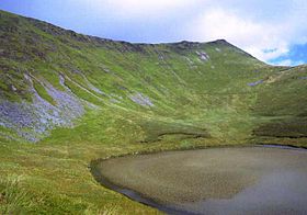
Cadair Berwyn and Llyn LluncawsElevation 830 m (2,723 ft) Prominence 344 m (1,129 ft) Parent peak Aran Fawddwy Listing Marilyn, Hewitt, council top, Nuttall Translation White-rick chair (Welsh) Pronunciation Welsh: [ˈkadair ˈbɛrwɨn] Location Location Denbighshire / Powys,  Wales
WalesRange Berwyn range Topo map OS Landranger 125 OS grid SJ071323 Listed summits of Cadair Berwyn Name Grid ref Height Status Moel Sych SJ066318 827 metres (2,713 ft) Hewitt, Nuttall Cadair Berwyn North Top SJ066318 827 metres (2,713 ft) Nuttall Cadair Bronwen SJ066318 785 metres (2,575 ft) Hewitt, Nuttall Tomle SJ085335 742 metres (2,434 ft) sub Hewitt, Nuttall Moel yr Ewig SJ080317 695 metres (2,280 ft) sub Hewitt, Nuttall Foel Wen SJ099334 691 metres (2,267 ft) Hewitt, Nuttall Mynydd Tarw SJ112324 681 metres (2,234 ft) Hewitt, Nuttall Godor SJ094307 679 metres (2,228 ft) sub Hewitt, Nuttall Godor North Top SJ089311 675 metres (2,215 ft) Nuttall Post Gwyn SJ085335 665 metres (2,182 ft) Hewitt, Nuttall Moel Fferna SJ085335 630 metres (2,067 ft) Hewitt, Nuttall Pen Bwlch Llandrillo SJ085335 621 metres (2,037 ft) Hewitt, Nuttall Glan-hafon SJ085335 608 metres (1,995 ft) sub Hewitt Pen Bwlch Llandrillo East Top SJ085335 604 metres (1,982 ft) sub Hewitt Cadair Berwyn or Cader Berwyn is a mountain summit in north east Wales. It is the highest point in the Berwyn range, and the highest significant summit in Wales outside the National Parks. Cadair Berwyn and Cyrniau Nod to the west are the two Marilyns that form the Berwyn range.[1]
The mountain lies on main ridge of the Berwyns which runs north–south. The eastern side of the ridge is characterised by steep drops and crags including Craig Berwyn north of the summit and Craig y Llyn to the south. Craig y Llyn forms the headwall of a cwm, and it is to this that the word cadair (chair in Welsh) presumably refers. Further north along the ridge is Cadair Bronwen, whilst to south the ridge continues to Moel Sych (Welsh pronunciation: [ˈmɔil ˈsɨːx], meaning 'dry hill').
It is often reported that Moel Sych, 1 km along the ridge, is of equal height, but Cadair Berwyn's spot height on the Ordnance Survey maps, where the trig point stands, is not the true summit. Cadair Berwyn's summit, 200 m south of the trig point, is three metres taller than Moel Sych. This summit is listed as Cadair Berwyn New Top on the Nuttall list.
Several other summits in the area are listed as Hewitts or Nuttalls, including Foel Wen ([ˈvɔil ˈwɛn], Welsh for white hill) and Mynydd Tarw ([ˈmɐnɨð ˈtæɾu], bull mountain).
The summit lies on the border between Powys and Denbighshire, and is the highest point in Denbighshire. The northern end Craig Berwyn is the highest point in Wrexham county borough.
There is a standing stone in the area, located near the summit between Cadair Berwyn and Tomle. This was re-erected in June 2008 by High Sports. The standing stone can be found at SJ080337[2].
References
- ^ Nuttall, John & Anne (1999). The Mountains of England & Wales - Volume 1: Wales (2nd edition ed.). Milnthorpe, Cumbria: Cicerone. ISBN 1-85284-304-7.
- ^ High Sports. "Cadair Berwyn Standing Stone". http://www.highsports.co.uk/blog/?p=104. Retrieved June 10, 2008. (English)
External links
- Computer generated summit panoramas Cadair Berwyn index
- www.geograph.co.uk : photos of Cadair Berwyn and surrounding area
Categories:- Marilyns of Wales
- Hewitts of Wales
- Mountains and hills of north Wales
- Nuttalls

Wikimedia Foundation. 2010.