- Terevaka
-
Main article: Easter Island#Geology
Mauga Terevaka Elevation 507.41 m (1,665 ft) Location Location Easter Island Coordinates 27°5′4″S 109°22′46″W / 27.08444°S 109.37944°WCoordinates: 27°5′4″S 109°22′46″W / 27.08444°S 109.37944°W Ma′unga Terevaka is the largest, tallest (507.41 m (1,664.73 ft)) and youngest of three main extinct volcanoes that form Rapa Nui (Easter Island) (a Chilean island in the Pacific Ocean). Several smaller volcanic cones and craters dot its slopes, including a crater hosting one of the island's three lakes, Rano Aroi.
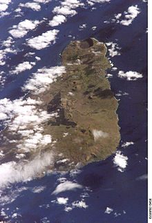 Terevaka from space with Hanga Roa above and Rano Kau at top - a west up photo from Nasa
While Terevaka forms the bulk of Easter Island, the island has two older volcanic peaks; Poike which forms the eastern headland and Rano Kau the southern. Terevaka last erupted in the Pleistocene and is less than 400,000 years old. Its lava field at Roiho has been dated at between 110,000 and 150,000 years old. Terevaka is rather difficult to climb, and is only accessible by foot or horse. It is very windy at the top.
See also
References
- Haase, Karsten M.; Peter Stoffers and C. Dieter Garbe-Schönberg (October 1997). "The Petrogenetic Evolution of Lavas from Easter Island and Neighbouring Seamounts, Near-ridge Hotspot Volcanoes in the SE Pacific". Journal of Petrology 38 (06): 785–813. doi:10.1093/petrology/38.6.785. http://www.oxfordjournals.org/our_journals/petroj/online/Volume_38/Issue_06/html/ega038_gml.html. Retrieved 2010-03-16.
- Kaneoka I, Katsui Y, 1985. K-Ar ages of volcanic rocks from Easter Island. Bull Volc Soc Japan, 30: 33-36.
- Vezzoli L, Acocella V, 2009. Easter Island, SE Pacific: an end-member type of hotspot volcanism. Geol Soc Amer Bull, 121: 869-886.
External links
- Guide to Easter Island from the Easter Island Foundation
- Old photos of Rano Aroi (upper right)
Categories:- Extinct volcanoes
- Pleistocene volcanoes
- Crater lakes
- Volcanoes of Easter Island
- Chile geography stubs


Wikimedia Foundation. 2010.