- 2003 Colima earthquake
Earthquake
title = 2003 Colima earthquake
date =January 21 2003
magnitude = 7.6 Mw
depth= convert|24|km|mi|0
location = 18.84N 103.82W
countries affected = Flag|Mexico
tsunami = None
aftershocks =
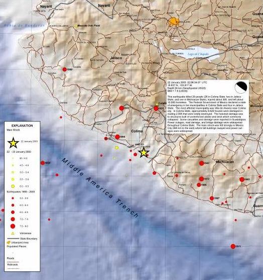
casualties = 29 (dead) 300 (injured)The 2003 Colima earthquake registered a magnitude of 7.6 on theRichter scale , and it occurred onJanuary 21 ,2003 . The center of the earthquake was located on thePacific coast , in the State ofColima ,Mexico . The earthquake was felt as far asMexico City .Effects
At least 29 people were killed, 300 injured, about 10,000 homeless, 2,005 houses destroyed and 6,615 damaged. Most of the deaths and damage occurred in the
Villa de Alvarez -Colima area. Extensive damage (VIII) at Colima and Tecoman. Some deaths and damaged occurred in Jalisco and Michoacan and a few buildings were damaged in Guanajuato and Morelos. Felt strongly (VI) in parts of Mexico City. Felt in central and southwestern Mexico from Nayarit and San Luis Potosi to Puebla andTlaxcala . Also felt at Corpus Christi, Dallas, El Paso and by people in high-rise buildings at Houston, Texas. Landslides closed a segment of the Colima-Guadalajara Highway and the port at Manzanillo. Power and telephone outages occurred in Mexico City. A local tsunami of about 1 m (peak-to-trough) was recorded at Manzanillo. A seiche was observed on Lake Pontchartrain and sediment was stirred up in wells in Louisiana. [ [http://neic.usgs.gov/neis/eq_depot/2003/eq_030122/ USGS NEIC: Earthquake Bulletin: COLIMA, MEXICO ] ]Tectonic summary
This shallow earthquake occurred in a seismically active zone near the coast of central Mexico. The earthquake occurred near the juncture of three tectonic plates: the North American Plate to the north-east, the Rivera Plate to the north-west, and the Cocos Plate to the south. Both the Rivera Plate and the Cocos Plate are being consumed beneath the North American Plate. The slower subducting Rivera Plate is moving north-west at about 2 cm per year relative to the North American Plate and the faster Cocos plate is moving in a similar direction at a rate of about 4.5 cm per year.
There have been several significant earthquakes near the recent event. In 1932, a magnitude 8.4 thrust earthquake struck about 100 km to the north-north-west. More recently, on October 9, 1995 a magnitude 8.0 earthquake struck about 50 km to the north-west killing at least 49 people and leaving 1,000 homeless. The most deadly earthquake in the region occurred about 170 km to the south-east on September 19, 1985. This magnitude 8.0 earthquake killed at least 9,500 people, injured about 30,000, and left 100,000 people homeless. [ [http://neic.usgs.gov/neis/eq_depot/2003/eq_030122/ USGS NEIC: Earthquake Bulletin: COLIMA, MEXICO ] ]
References
Wikimedia Foundation. 2010.