- Ptolemaida
Infobox Greek Dimos
name = Ptolemaida
name_local = Πτολεμαΐδα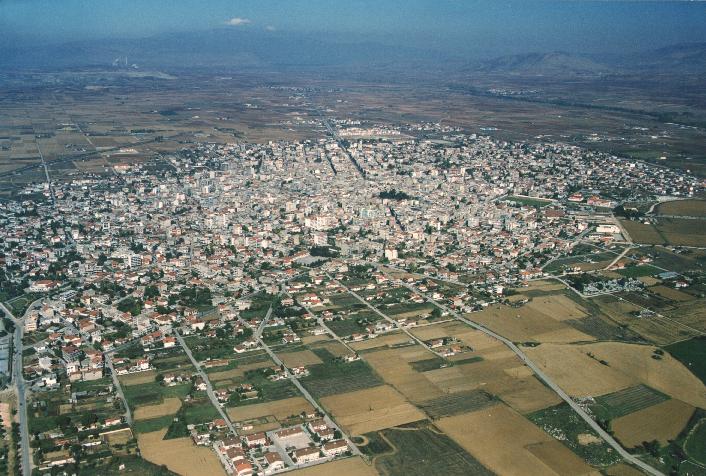
caption_skyline =
city_
city_
lat_deg = 40
lat_min = 31
lon_deg = 21
lon_min = 41
elevation_min =
elevation_max =
periph =West Macedonia
prefec = Kozani
municipality =
districts =
mayor = Grigorios Tsioumaris
party =
since =
population_as_of = 2001
population = 35539
area = 217.901
population_metro =
area_metro =
postal_code = 502 00
area_code = 24630
licence = KZ
website = [http://www.ptolemaida.gr www.ptolemaida.gr]Ptolemaida ( _el. Πτολεμαΐδα, "Ptolemaïda" or
Katharevousa : Πτολεμαΐς, "Ptolemaïs") is a city in NorthernGreece . It lies in the prefecture ofKozani , which is part of the periphery ofWest Macedonia . It is known for its coal (lignite ) mines and itspower station s.Name
*
Modern Greek : Πτολεμαΐδα "Ptolemaida"
*Katharevousa : Πτολεμαΐς "Ptolemais"
*Turkish: "Kayılar", "Kaylar", "Kayalar", "Kailar"
*South Slavic language : Кайляри/Кајлари – "Kailari" or Кайляр/Кајљар – "Kailyar"In the Ottoman period, the city was named Kaylar, and this name was retained in Greek, in the form "Kailaria" (Καϊλάρια) until 1927. The modern name Ptolemaida was introduced by decree on
January 20 ,1927 . The name was chosen in honor of Ptolemy son of Lagus, a comrade-in-arms ofAlexander the Great , and his daughter Ptolemaïs [cite web |url=http://www.ptolemaida.net/p-istoria.html |title=el iconPtolemaida Web Portal|accessdate=2008-01-10 |format= |work=] . His statue stands in the central square of the city.Location
The city lies in the valley of
Eordaia , between theAskio mountains to the southwest and theVermio mountains to the northeast. It is located north of Kozani, east of Kastoria, south ofFlorina , and south-west of Edessa. Since the 1960s, GR-3/E65 has bypassed it to the east. It is the seat of the province ofEordia .History
According to archaeologists, the Ptolemaida region has been occupied since 6000 BCE.cite news |first=Costas |last=Kantouris |title=Greek Hiker Finds 6,500-Year-Old Pendant |date=February 16, 2006 |publisher=AP |url=http://news.yahoo.com/s/ap/20060217/ap_on_re_eu/greece_ancient_pendant]
Neolithic times
Archaeologists, in November 2005, discovered the remains of two farming villages dating back to the
Neolithic period. A press report notes that such farming villages were trading centres and had a "developed knowledge of metalworking".A golden necklace dating to roughly 4500 BCE was discovered on
February 16 ,2006 .Associated Press reporter Costas Kantouris describes the item as a "flat, roughly ring-shaped [which] probably had religious significance and would have been worn on a necklace by a prominent member of society."Lately in the lake Zazari near Ptolemaida there were found 16 houses that belong in the Neolithic era due to archaaeologists.These houses were in the lake and were exposed because of the decreased water level of the lake.That particular small settlement gives information about the society and the people in the Neolithic era.
Ancient period
In the area of Ptolemaida many findiings have beek revelead the last 30 years due to mining operations.Ceramic artifacts, dating to the 6th century BC, are one of many unrevealed at two sites near
Grevena and Ptolemaida. Archaeologists found the artifacts at two prehistoric farming settlements. The findings will shed light on the social structures of the Neolithic era.There are also found at least two Ancient Makedonian graves in the area of Ptolemaida.These graves are dated from the 5th century BC and give many information about the architecture that was used at that time and also about the customs that people had.Byzantine Period
At various times, Ptolemaida was part of the
Latin Empire , theKingdom of Thessalonica , theEmpire of Nicaea , and theDespotate of Epirus .Fact|date=June 2007 The borders among the Latin Empire, the Empire of Nicaea, the Empire of Trebizond, and the Despotate of Epirus are very uncertain.Ottoman period
During the Ottoman period, Ptolemaida was called Kailar, and it had two parts: Ashai Kayılar and Ukarı Kayılar. Asai Kayılar was
Bektashi and Ukari Kailar wasRufai ,hanefi (naturalist)Fact|date=June 2007.Before 1360, large numbers of
nomad shepherds , orYuruks , from the district ofKonia , inAsia Minor , had settled in Macedonia; their descendants were known asKonariotes Fact|date=June 2007. Further immigration from this region took place from time to time up to the middle of the 18th century. After the establishment of thefeudal system in 1397, many of the Seljuknoble families came over fromAsia Minor ; their descendants may be recognized among theBeys orMuslim landowners in KailarFact|date=June 2007. At the beginning of the 18th century, the Turkish population was quite considerable, but since that time it has continuously decreased. A low birth rate, the exhaustion of the male population bymilitary service , and a large mortality fromepidemic s have brought about a decline which has lately been hastened byemigration . The Turkish rural population around Kailar was mainly composed ofKonariot shepherdsFact|date=June 2007. Ptolemaida was taken by Greek forces onOctober 15 1912 .Culture
Ptolemaida's football club is called "
Eordaikos " ( _el. Εορδαϊκός). Other teams includeAE Ptolemaidas . Ptolemaida has schools,lyceum s, gymnasia, churches, banks, a post office, a train station (Kozani -Florina ), a police station, a water tower, and squares ("plateies"). There is the potential of a university being established by the state in the near future, which will raise the standard of life in Ptolemaida.Economy
Ptolemaida is a highly industrialized area. The four
power plant s in this area produce 70% of Greece's electrical power, using the large local deposits oflignite as fuel. The plants are owned by thePublic Power Corporation (DEI), the major employer in the city. The plant was dedicated by the prime minister of Greece at that time,Constantine Karamanlis . The other two are inAmyntaio in Florina and in Agios Dimitrios.Climate
The city, situated in the middle of the
Eordaia plain ofWestern Macedonia , has a continental climate. Summers can be hot with thunderstorms in unsettled spells, whereas winters are among the coldest inGreece . It is here that the absolute low temperature record of the country was recorded (-27.8ºC in January 1969).Demographics
The current Municipality of Ptolemaida is constituted by the city of Ptolemaida and 12 small communities which all together cover an extent of 2.179 square kilometres.
At the 2001
census , the population of the city was 30,017 residents.The total population of the municipality in 1991 was 32,775 residents.
However, it is likely that these elements underestimate the real population because of the tendency of certain residents to be recorded at the national censuses in their home village. Thus, the real Population of Ptolemaida is around 50.000
Ethnic groups
A substantial proportion of Ptolemaida's residents are Pontic Greek from Sourmene or
Sürmene , TurkeyFact|date=January 2007 or their descendants. These were refugees fromAsia Minor who first arrived in Macedonia during the 1920s as a result of the population exchange according to theTreaty of Lausanne . These replaced the Turkish population in the area in much larger numbers, resulting in the doubling of the general population.Fact|date=January 2007Famous people
*
Pantelis Kapetanos
*Mara Darmousli (1982) fashion modelFriendship towns
*flagicon|Cyprus
Enkomi ,Cyprus
*Most ,Czech Republic ee also
*
List of communities of Kozani References
External links
* [http://www.ptolemaida.net Ptolemaida news]
*http://hellas.teipir.gr/Thesis/Eordaia/english/Ptolemaida.htm
* [http://www.mapquest.com/maps/map.adp?tb=1&city=Ptolemaida&country=GR Mapquest - Ptolemaida] , street map not yet available
* [http://www.meteo.gr/stations/ptolemaida Weather station of the National Observatory of Athens in Ptolemaida]
*Coordinates: coord|40|30|40|N|21|40|41|E|region:GR
Wikimedia Foundation. 2010.