Disenchantment Bay

Disenchantment Bay
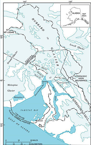
Map of Disenchantment Bay

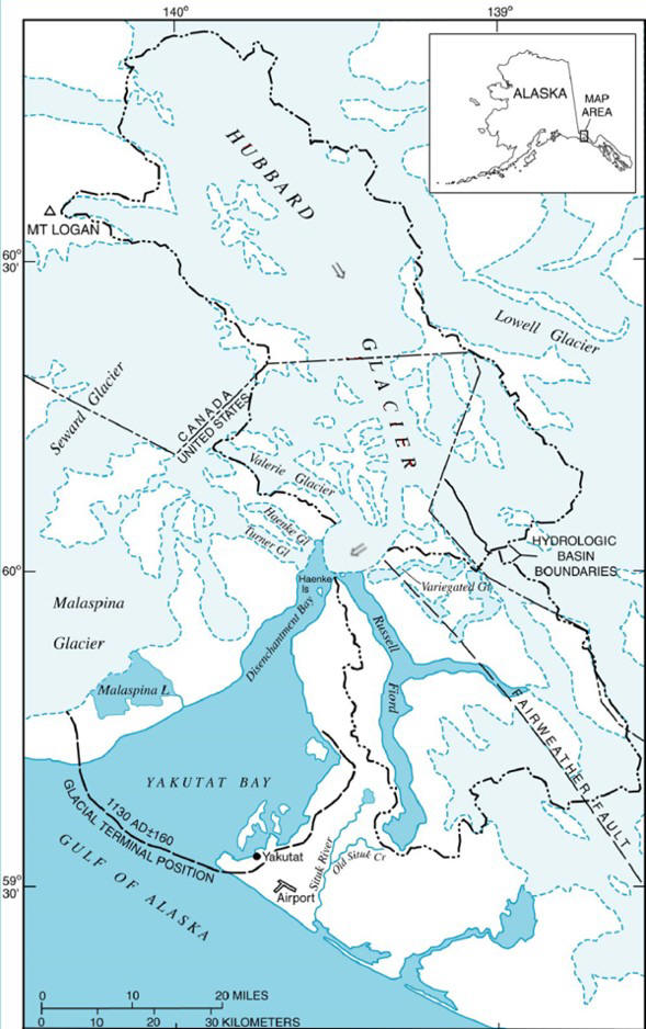
Disenchantment Bay extends southwest for 16 km (10 mi) from the mouth of Russell Fiord to Point Latouche, at the head of Yakutat Bay in Alaska.

Named "Puerto del Desengano", Spanish for "bay of disenchantment", by Alessandro Malaspina in 1792, upon finding that the bay was not the entrance to the legendary Northwest Passage. He sailed up the bay as far as Haenke Island, before discovering the passage blocked by ice.[1]

During the earthquake of September 10, 1899, parts of Disappointment bay were raised 47 feet 4 inches (14 metres). This is the greatest recorded vertical displacement by an earthquake.[2]

References

  1. ^ U.S. Geological Survey Geographic Names Information System: Disenchantment Bay
  2. ^ Lane, F.W. The Elements Rage (David & Charles 1966), p.176n.

Coordinates: 59°57′43″N 139°34′12″W / 59.96194°N 139.57°W / 59.96194; -139.57


Wikimedia Foundation. 2010.

Игры ⚽ Нужен реферат?

Look at other dictionaries:

  • Disenchantment Bay — Karte der Yakutat Bay mit der Disenchantment Bay im Nordosten Die Disenchantment Bay ist eine Bucht am Fuße der Eliaskette im Südosten von Alaska am Übergang zum Panhandle. Sie grenzt bei Point Latouche an die Yakutat Bay, eine Bucht des Golfs… …   Deutsch Wikipedia

  • Erdbeben in der Yakutat Bay 1899 — Die Erdbeben in der Yakutat Bay 1899 ereigneten sich zwischen dem 4. und 10. September in der Umgebung der Yakutat Bay. Dem Hauptbeben am 10. September ging am gleichen Tag um 17:04 UTC ein Beben mit der Stärke 7,8 voran.[1] Das Hauptbeben… …   Deutsch Wikipedia

  • Yakutat Bay — carte de la Yakutat Bay …   Wikipédia en Français

  • Yakutat Bay — Karte der Yakutat Bay Die Yakutat Bay ist eine 29 km breite Bucht im US Bundesstaat Alaska, im Nordosten begrenzt von der Disenchantment Bay, im Südwesten durch den Golf von Alaska …   Deutsch Wikipedia

  • Yakutat Bay — is a 29 km wide (18 mi) bay in the U.S. state of Alaska, extending southwest from Disenchantment Bay to the Gulf of Alaska. Yakutat is a Tlingit name reported as Jacootat and Yacootat by Yuri Lisianski in 1805. La Pérouse, who visited it in 1786 …   Wikipedia

  • Russell-Fjord — 59.932312 139.373932 Koordinaten: 59° 55′ 56″ N, 139° 22′ 26″ W …   Deutsch Wikipedia

  • Hubbard Gletscher — Karte des Hubbard Gletschers. Gut zu erkennen ist, die bevorstehende Trennung von Russell Fjord und Disenchantment Bay. Der Hubbard Gletscher ist ein Gletscher in der Eliaskette im US Bundesstaat Alaska und dem Yukon Territorium. Von seiner… …   Deutsch Wikipedia

  • Haenke Island — Vorlage:Infobox Insel/Wartung/Höhe fehlt Haenke Island Haenke Island in der Disench …   Deutsch Wikipedia

  • Hubbard-Gletscher — Karte des Hubbard Gletschers. Gut zu erkennen ist, die bevorstehende Trennung von Russell Fjord und Disenchantment Bay. Der Hubbard Gletscher ist ein Gletscher in der Eliaskette im US Bundesstaat Alaska und dem Yukon Territorium. Von seiner… …   Deutsch Wikipedia

  • Hubbard Glacier — Infobox Glacier | glacier name = Hubbard Glacier caption = Hubbard Glacier type = Tidewater/Mountain glacier location = Yakutat City and Borough, Alaska, U.S., Yukon, Canada coordinates = coord|60|00|54|N|139|29|31|W|type:glacier… …   Wikipedia

Share the article and excerpts

Direct link
Do a right-click on the link above
and select “Copy Link”