- Hubbard Glacier
Infobox_Glacier | glacier_name = Hubbard Glacier
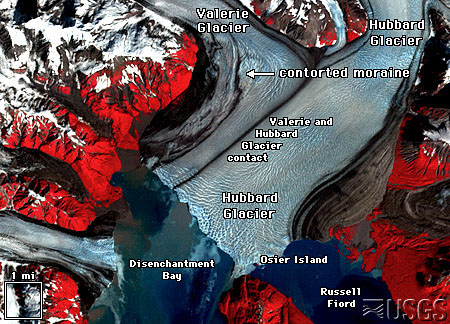
caption = Hubbard Glacier
type = Tidewater/Mountain glacier
location =Yakutat City and Borough, Alaska , U.S.,Yukon ,Canada
coordinates = coord|60|00|54|N|139|29|31|W|type:glacier_region:US/CA|display=inline,title
area =
length = 122 km (76 miles)
thickness =
terminus = Sealevel
status = Stable/AdvancingHubbard Glacier is a tidewater
glacier in theU.S. state ofAlaska and theYukon Territory ofCanada . From its source in the Yukon, the glacier stretches 122 km (76 mi) to the sea atYakutat Bay andDisenchantment Bay . It is the longest tidewater glacier in Alaska, with an open calving face over ten kilometers (6 mi) wide. [cite web| url = http://www.nps.gov/wrst/hubbardglacier.htm| title = Hubbard Glacier: Geology in Action!| publisher = National Park Service| accessdate = 2007-01-17]Details
Hubbard Glacier’s longest source, 122 km from its snout, is at about 11,000 feet above sea level at about 61-00N 140-09 W, about eight kilometers west of Mt. Walsh. A shorter tributary glacier begins at the easternmost summit on the Mt. Logan ridge at about 18,300 feet at about 60-35 N 140-22-40 W.
Before it reaches the sea, Hubbard is joined by the Valerie Glacier to the west, which, through forward surges of its own ice, has contributed to the advance of the ice flow that experts believe will eventually dam the
Russell Fiord from Disenchantment Bay waters.The Hubbard Glacier ice margin has continued to advance for about a century. In
May 1986 , the Hubbard Glacier surged forward, blocking the outlet of Russell Fiord and creating "Russell Lake." All that summer the new lake filled with runoff; its water level rose 25 meters, and the decrease insalinity threatened its sea life.cite web| url = http://water.usgs.gov/pubs/fs/fs-001-03/| title = USGS Report: Hubbard Glacier, Alaska: Growing and Advancing in Spite of Global Climate Change and the 1986 and 2002 Russell Lake Outburst Floods|publisher = U.S. Geological Survey| accessdate = 2007-01-18]Around midnight on
October 8 the dam began to give way. In the next 24 hours an estimated 5.3 km³ of water gushed through the gap, and thefiord was reconnected to the ocean at its previous level. This was the second largestglacial lake outburst flood (GLOF) in recorded history.In spring 2002, the glacier again approached Gilbert Point. It pushed a terminal
moraine ahead of its face and closed the opening again in July. OnAugust 14 , the terminal moraine was washed away after rains had raised the water level behind the dam it formed to 18 m (61 ft) above sea level.Cite web
url=http://ak.water.usgs.gov/glaciology/hubbard/photos/index.htm
title=2002 Russell Fiord Closure and Russell Lake Outburst
accessdate=2007-07-07
date=January 3, 2007
work=Water Resources of Alaska • Glacier and Snow Program
publisher=U.S. Geological Survey] The fiord could become dammed again, and perhaps permanently. If this happens, the fiord could overflow its southern banks and drain through the Situk River instead, threateningtrout habitat and a local airport.The ice at the foot of Hubbard Glacier is about 400 years old: it takes that long for ice to traverse the length of the glacier. The glacier routinely calves off
iceberg s the size of a ten-story building. Where the glacier meets the shore, most of the ice is below the waterline, and newly calved icebergs can shoot up quite dramatically, so that ships must keep their distance from it as they ply their way up and down the coast.Cited references
ee also
*
Glacial lake outburst flood
*List of glaciers External links
* [http://earthshots.usgs.gov Earthshots: Satellite Images of Environmental Change] , U.S. Geological Survey
* [http://maps.google.com/maps?ll=60.031244,-139.551773&spn=0.163902,0.463142&t=k&hl=en Google Maps: Interactive satellite view of where Hubbard Glacier meets the sea]
* [http://ak.water.usgs.gov/glaciology/hubbard/photos/index.htm U.S. Geological Survey: Sequence of photographs showing the 2002 ice blockage and breakthrough]Image gallery
Wikimedia Foundation. 2010.