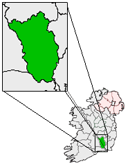
County Kilkenny — For other uses, see Kilkenny (disambiguation). County Kilkenny Contae Chill Chainnigh Coat of a … Wikipedia
Denis Heaslip — Personal information Irish name Donncha Heaslip Sport Hurling … Wikipedia
Langrishe Baronets — The Langrishe Baronetcy of Knocktopher Abbey in the County of Kilkenny is a title in the Baronetage of Ireland. It was created on 19 February 1777 for Hercules Langrishe, who represented Knocktopher in the Irish House of Commons.The family seat… … Wikipedia
Frank Cummins — Infobox GAA player code= Hurling sport = Hurling name = Frank Cummins irish = Prionsias Ó Cuimin fullname = Frank Cummins placeofbirth = Knocktopher countryofbirth = County Kilkenny dob = 1947 height = nickname = county = Kilkenny province =… … Wikipedia
Motorways in the Republic of Ireland — Planned National Roads Network for 2015. Main article: Roads in Ireland In Ireland, the highest category of road is a Motorway (mótarbhealach, plural: mótarbhealaí), indicated by the prefix M followed by one or two digits. The Motorway network… … Wikipedia
N9 road (Ireland) — N9 road Route information Length: 111 km (69 mi) Location … Wikipedia
N10 road (Ireland) — N10 road Location Primary destinations: County Kilkenny Paulstown – (N9 from Dublin) (N77 to Dur … Wikipedia
Mullinavat — Muileann an Bhata Town … Wikipedia
M9 motorway (Ireland) — For M9 motorway in Scotland, please click here. IRL motorway routebox parent = motorway = M9 length km = 24.5 length mi = 15.3 direction = N S start = Kilcullen destinations = Athy,Carlow end = Leighlinbridge opening date = 1993 completion date … Wikipedia
Liste Des Autoroutes D'Irlande — La signalisation routière bilingue est utilisée à travers toute l Irlande. Le réseau autoroutier irlandais est l un des plus récents d Europe et est actuellement en pleine expansion. Il peut être schématisé par une étoile dont le point de… … Wikipédia en Français