- Needles Airport
-
Needles Airport 
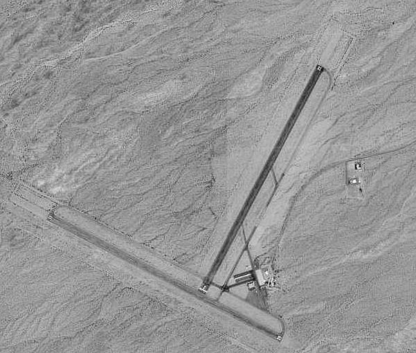
USGS aerial image, 21 May 1994 IATA: EED – ICAO: KEED – FAA LID: EED Summary Airport type Public Owner County of San Bernardino Serves Needles, California Elevation AMSL 983 ft / 300 m Coordinates 34°45′59″N 114°37′24″W / 34.76639°N 114.62333°W Website Runways Direction Length Surface ft m 2/20 4,235 1,291 Asphalt 11/29 5,005 1,526 Asphalt Statistics (2006) Aircraft operations 10,500 Based aircraft 8 Source: Federal Aviation Administration[1] Needles Airport (IATA: EED, ICAO: KEED, FAA LID: EED) is a county-owned, public-use airport in San Bernardino County, California, United States. It is located five nautical miles (9 km) south of the central business district of Needles.[1] According to the FAA's National Plan of Integrated Airport Systems for 2009–2013, it is categorized as a general aviation airport.[2]
The airfield was opened in May 1941. During World War II the airfield was known as Needles Army Airfield and was used by the United States Army Air Forces Fourth Air Force. With the end of the war, the base was declared excess to requirements and returned to civil control.
Contents
Facilities and aircraft
Needles Airport covers an area of 796 acres (322 ha) at an elevation of 983 feet (300 m) above mean sea level. It has two asphalt paved runways: 2/20 is 4,235 by 100 feet (1,291 x 30 m) and 11/29 is 5,005 by 100 feet.[1]
For the 12-month period ending February 17, 2006, the airport had 10,500 general aviation aircraft operations, an average of 28 per day. At that time there were 8 aircraft based at this airport: 62.5% single-engine and 37.5% ultralight.[1]
See also
References
- ^ a b c d FAA Airport Master Record for EED (Form 5010 PDF). Federal Aviation Administration. Effective 8 April 2010.
- ^ National Plan of Integrated Airport Systems for 2009–2013: Appendix A: Part 1 (PDF, 1.33 MB). Federal Aviation Administration. Updated 15 October 2008.
External links
- Needles Airport at San Bernardino County website
- Aerial image as of 21 May 1994 from USGS The National Map
- FAA Terminal Procedures for EED, effective 20 October 2011
- Resources for this airport:
- AirNav airport information for KEED
- ASN accident history for EED
- FlightAware airport information and live flight tracker
- NOAA/NWS latest weather observations
- SkyVector aeronautical chart, Terminal Procedures for KEED
Categories:- Airports in San Bernardino County, California
- Airfields of the United States Army Air Forces in California
- Military facilities in the Mojave Desert
- Mojave Desert
Wikimedia Foundation. 2010.