- Sehmatal
-
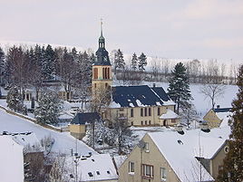
Sehmatal the church in Cranzahl 
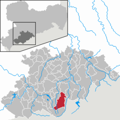
Coordinates 50°31′0″N 12°59′0″E / 50.516667°N 12.983333°ECoordinates: 50°31′0″N 12°59′0″E / 50.516667°N 12.983333°E Administration Country Germany State Saxony Admin. region Chemnitz District Erzgebirgskreis Local subdivisions 3 Mayor Udo Ott Basic statistics Area 44.45 km2 (17.16 sq mi) Elevation 700-800 m Population 7,048 (31 December 2010)[1] - Density 159 /km2 (411 /sq mi) Other information Time zone CET/CEST (UTC+1/+2) Licence plate ERZ Postal code 09465 Area code 037342 Website www.sehmatal.de Sehmatal is a municipality in the district of Erzgebirgskreis, in Saxony, Germany, which was created in 1999 through the union of Neudorf, Cranzahl and Sehma. The three villages are located along the Sehma river, aligned in a north-south direction. At the northern end is the former village of Sehma, in the middle the town of Cranzahl, to the south the village of Neudorf.
The town borders to Annaberg-Buchholz in the north, in the east is Königswalde and Bärenstein, Oberwiesenthal is south and Crottendorf in the west. Nearby is the Bärenstein mountain with a height of 898 meters. The Zschopau Valley Railway stops in Sehma and Cranzahl. At the station in Cranzahl is the starting point for the Fichtelberg Railway to Oberwiesenthal.
Neudorf is the home town of Olympic gold medalist Viola Bauer.
Sehmatal's sister city in the United States is Running Springs, California.
References
- ^ "Bevölkerung des Freistaates Sachsen jeweils am Monatsende ausgewählter Berichtsmonate nach Gemeinden" (in German). Statistisches Landesamt des Freistaates Sachsen. 31 December 2010. http://www.statistik.sachsen.de/download/010_GB-Bev/Bev_Gemeinde.pdf.
Amtsberg · Annaberg-Buchholz · Aue · Auerbach · Bad Schlema · Bärenstein · Bernsbach · Bockau · Börnichen · Borstendorf · Breitenbrunn · Burkhardtsdorf · Crottendorf · Deutschneudorf · Drebach · Ehrenfriedersdorf · Eibenstock · Elterlein · Erlbach-Kirchberg · Gelenau · Geyer · Gornau · Gornsdorf · Großolbersdorf · Großrückerswalde · Grünhain-Beierfeld · Grünhainichen · Heidersdorf · Hohndorf · Hormersdorf · Jahnsdorf · Johanngeorgenstadt · Jöhstadt · Königswalde · Lauter · Lengefeld · Lößnitz · Lugau · Marienberg · Mildenau · Neukirchen · Niederdorf · Niederwürschnitz · Oberwiesenthal · Oelsnitz · Olbernhau · Pfaffroda · Pobershau · Pockau · Raschau-Markersbach · Scheibenberg · Schlettau · Schneeberg · Schönheide · Schwarzenberg · Sehmatal · Seiffen · Stollberg · Stützengrün · Tannenberg · Thalheim · Thermalbad Wiesenbad · Thum · Wolkenstein · Zöblitz · Zschopau · Zschorlau · Zwönitz
 Categories:
- Municipalities in Saxony
- Saxony geography stubs
Wikimedia Foundation. 2010.


