- Counter's Creek
-
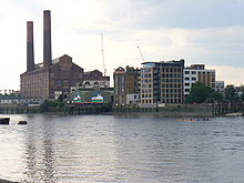 Lots Road power station where Counter's Creek joins the Thames as Chelsea Creek
Counter's Creek is a largely subterranean stream that arises in Kensal Green, west London and flows south into the River Thames on the Tideway at Sands End, Chelsea. Two small tributaries that rise just west of Ladbroke Grove enter the stream close to Latimer Road just south of St Quintin Avenue.[1]
The stream flows south through Kensal Green Cemetery, Little Wormwood Scrubs, North Kensington, Shepherds Bush, Olympia and Earl's Court. It can be seen (particularly after heavy rainfall) or otherwise as a verdant ditch beside Platform 4 (trains to Olympia) of West Brompton Underground Station. It passes Brompton Cemetery and Chelsea F.C. ground at Stamford Bridge. On the left bank where the creek meets the Thames is the former Lots Road Power Station. The tidal mouth is shown on modern maps as Chelsea Creek.
The upper reaches have been variously known as Billingswell Ditch, Pools Creek and Counters Creek. In mediaeval times the Creek was known as Billingwell Dyche, derived from 'Billing's spring or stream'. It formed the boundary between the parishes of Kensington and Fulham. By the eighteenth century the creek had become known as Counter's Creek, which is believed to derive from 'Counter's Bridge' which crossed the creek at the west end of Kensington High Street. This was first recorded in the fourteenth century as 'Countessesbrugge', and may be called after Matilda, Countess of Oxford, who then held the manor of Kensington.[2] 'Stamford Bridge' is considered to be a corruption of 'Samfordesbrigge' meaning 'the bridge at the sandy ford'.[3] The existing Stamford Bridge was built of brick in 1860–2 and has been partly reconstructed since then. The name is more generally used to refer to the nearby Stamford Bridge Stadium, which is the home of Chelsea Football Club. In 1824–8 the lower part of the creek was developed into the Kensington Canal. This was taken over by the Bristol Birmingham & Thames Junction Railway in the 1830s and subsequently much was culverted to take the West London Line along its course in 1859–63.[4] This railway route provides a link between Clapham Junction and Willesden Junction. The waters of the ancient sewer were diverted underground and only the lower reach remained in use, supplying coal to Sands End gas works and later to the power station.[5] The stream was visible as a surface river on the west side of Little Wormwood Scrubs on Ordnance Survey maps pre-1930. However, by the 1930 Ordnance Survey the river had already been covered under ground.
See also
- Tributaries of the River Thames
- Subterranean rivers of London
- List of rivers in England
References
- ^ Nicholas Barton The Lost Rivers of London 1962 ISBN 0948667
- ^ J. E. B. Gover, Allen Mawer and F. M. Stenton, The Place-Names of Middlesex 1942
- ^ Charles James Feret Fulham Old and New vol. ii, 1900
- ^ The Kensington Canal, railways and related developments, Survey of London: volume 42: Kensington Square to Earl's Court (1986), pp. 322-338. Date accessed: 02 September 2008.
- ^ British History Online Stamford Bridge and the Billings area, Survey of London: volume 41: Brompton (1983)
- Tim Bradford 2004, 'The Groundwater Diaries', Flamingo, London, ISBN 0-00-713083-X
- Ed Glinert 2003, 'The London Compendium', Allen Lane, London, ISBN 0-713-99688-9
- List of rivers in England
- Subterranean rivers of London
Next confluence upstream River Thames Next confluence downstream River Wandle (south) Counter's Creek River Westbourne (north) Categories:- Subterranean rivers of London
- Tributaries of the River Thames
- Geography of Brent

Wikimedia Foundation. 2010.