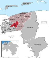
- Moorweg
-
Moorweg 
Coordinates 53°35′31″N 7°35′6″E / 53.59194°N 7.585°ECoordinates: 53°35′31″N 7°35′6″E / 53.59194°N 7.585°E Administration Country Germany State Lower Saxony District Wittmund Municipal assoc. Esens Local subdivisions 5 Ortsteile Mayor Dieter Tobias Basic statistics Area 18.65 km2 (7.20 sq mi) Elevation 2 m (7 ft) Population 896 (31 December 2010)[1] - Density 48 /km2 (124 /sq mi) Other information Time zone CET/CEST (UTC+1/+2) Licence plate WTM Postal code 26427 Area code 04977 Moorweg is a municipality in the district of Wittmund, in Lower Saxony, Germany.
Blomberg | Dunum | Esens | Eversmeer | Friedeburg | Holtgast | Langeoog | Moorweg | Nenndorf | Neuharlingersiel | Neuschoo | Ochtersum | Schweindorf | Spiekeroog | Stedesdorf | Utarp | Werdum | Westerholt | WittmundReferences
- ^ "Bevölkerungsfortschreibung" (in German). Landesbetrieb für Statistik und Kommunikationstechnologie Niedersachsen. 31 December 2009. http://www1.nls.niedersachsen.de/statistik/html/parametereingabe.asp?DT=K1000014&CM=Bev%F6lkerungsfortschreibung.
Categories:- Municipalities in Lower Saxony
- East Frisia stubs
- Weser-Ems region geography stubs
- Towns and villages in East Frisia
Wikimedia Foundation. 2010.


