- Oerel
-
Oerel 

 OerelLocation of Oerel within Rotenburg (Wümme) district
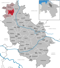

Coordinates 53°29′1″N 9°03′36″E / 53.48361°N 9.06°ECoordinates: 53°29′1″N 9°03′36″E / 53.48361°N 9.06°E Administration Country Germany State Lower Saxony District Rotenburg (Wümme) Municipal assoc. Geestequelle Local subdivisions 3 Mayor Helmut Ringe (SPD) Basic statistics Area 33.70 km2 (13.01 sq mi) Elevation 16 m (52 ft) Population 1,869 (31 December 2010)[1] - Density 55 /km2 (144 /sq mi) Other information Time zone CET/CEST (UTC+1/+2) Licence plate ROW Postal code 27432 Area codes 04761, 04765, 04766 Website www.geestequelle.de Oerel is a municipality in the district of Rotenburg, in Lower Saxony, Germany.
Oerel belonged to the Prince-Archbishopric of Bremen, established in 1180. In 1648 the Prince-Archbishopric was transformed into the Duchy of Bremen, which was first ruled in personal union by the Swedish Crown - interrupted by a Danish occupation (1712–1715) - and from 1715 on by the Hanoverian Crown. In 1807 the ephemeric Kingdom of Westphalia annexed the Duchy, before France annexed it in 1810. In 1813 the Duchy was restored to the Electorate of Hanover, which - after its upgrade to the Kingdom of Hanover in 1814 - incorporated the Duchy in a real union and the Ducal territory, including Oerel, became part of the new Stade Region, established in 1823.
Ahausen · Alfstedt · Anderlingen · Basdahl · Bötersen · Bothel · Breddorf · Bremervörde · Brockel · Bülstedt · Deinstedt · Ebersdorf · Elsdorf · Farven · Fintel · Gnarrenburg · Groß Meckelsen · Gyhum · Hamersen · Hassendorf · Heeslingen · Hellwege · Helvesiek · Hemsbünde · Hemslingen · Hepstedt · Hipstedt · Horstedt · Kalbe · Kirchtimke · Kirchwalsede · Klein Meckelsen · Lauenbrück · Lengenbostel · Oerel · Ostereistedt · Reeßum · Rhade · Rotenburg an der Wümme · Sandbostel · Scheeßel · Seedorf · Selsingen · Sittensen · Sottrum · Stemmen · Tarmstedt · Tiste · Vahlde · Vierden · Visselhövede · Vorwerk · Westertimke · Westerwalsede · Wilstedt · Wohnste · Zeven

References
- ^ "Bevölkerungsfortschreibung" (in German). Landesbetrieb für Statistik und Kommunikationstechnologie Niedersachsen. 31 December 2009. http://www1.nls.niedersachsen.de/statistik/html/parametereingabe.asp?DT=K1000014&CM=Bev%F6lkerungsfortschreibung.
Categories:- Municipalities in Lower Saxony
- Lüneburg region geography stubs


Wikimedia Foundation. 2010.