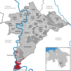
- Lauenförde
-
Lauenförde 
Coordinates 51°39′38″N 9°23′16″E / 51.66056°N 9.38778°ECoordinates: 51°39′38″N 9°23′16″E / 51.66056°N 9.38778°E Administration Country Germany State Lower Saxony District Holzminden Municipal assoc. Boffzen Local subdivisions 2 Mayor Andrea Tyrasa (SPD) Basic statistics Area 17 km2 (6.6 sq mi) Elevation 105 m (345 ft) Population 2,513 (31 December 2010)[1] - Density 148 /km2 (383 /sq mi) Other information Time zone CET/CEST (UTC+1/+2) Licence plate HOL Postal code 37697 Area code 05273 Lauenförde is a municipality in the district of Holzminden, in Lower Saxony, Germany.
ARMS
The arms were granted in 1927 and based on a seal of the Amt Lauenförde from 1779. The lion is the so-called Welfen-lion, indicating that the town belonged to this family. The waves symbolise the Weser. Lauenförde is situated on the Weser and used to be one of the major crossing points of this river. It has also been stated that the arms are canting, derived from Löwenfurt (Lion-ford).
Arholzen | Bevern | Bodenwerder | Boffzen | Brevörde | Deensen | Delligsen | Derental | Dielmissen | Eimen | Eschershausen | Fürstenberg | Golmbach | Halle | Hehlen | Heinade | Heinsen | Heyen | Holenberg | Holzen | Holzminden | Kirchbrak | Lauenförde | Lenne | Lüerdissen | Negenborn | Ottenstein | Pegestorf | Polle | Stadtoldendorf | Vahlbruch | Wangelnstedt
References
- ^ "Bevölkerungsfortschreibung" (in German). Landesbetrieb für Statistik und Kommunikationstechnologie Niedersachsen. 31 December 2009. http://www1.nls.niedersachsen.de/statistik/html/parametereingabe.asp?DT=K1000014&CM=Bev%F6lkerungsfortschreibung.
Categories:- Municipalities in Lower Saxony
- Hanover region geography stubs
Wikimedia Foundation. 2010.


