Elizabeth Vale, South Australia
- Elizabeth Vale, South Australia
Infobox Australian Place | type = suburb
name = Elizabeth Vale
state = sa
city = Adelaide
caption =
lga = City of Playford
lga2 = City of Salisbury
postcode = 5112
pop = 3231 (2001 est) [2001 Census, Australian Bureau of Statistics]
est = 1955
propval=$173,000(June 2007) [cite web
url= http://www.domain.com.au/Public/suburbprofile.aspx?mode=research&searchTerm=Elizabeth%20Vale#mapanchor
publisher=Domain.com.au
title=Elizabeth Vale suburb profile
year=2007
accessdate=2007-06-24 ]
stategov = Little Para
fedgov = Wakefield
near-w=Salisbury North
near-nw=Elizabeth South
near-nw=Edinburgh
near-n=Elizabeth
near-ne=Elizabeth East
near-e=Hillbank
near-se=Salisbury Heights
near-se=Greenwith
near-s=Salisbury Park
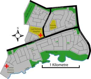
near-sw=SalisburyElizabeth Vale is a suburb in the northern extent of Adelaide, South Australia. It was established in 1955. Its main roads are Main North Road to the east and John Rice Avenue which bisects the suburb. The southern boundary is the northern bank of the Little Para River.
Elizabeth Vale has two hospitals, the Lyell McEwin Health Service, a public teaching hospital, and the private Central Districts Hospital.
ee also
*Elizabeth Vale Soccer Club
*City of Playford
*List of Adelaide suburbs
References
External links
* [http://www.playford.sa.gov.au/ Playford Council]
* [http://www.geocities.com/Heartland/Canyon/9069/ Playford History Centre]
* [http://www.lmhsadelaide.sa.gov.au/ Lyell McEwin Health Services]
Wikimedia Foundation.
2010.
Look at other dictionaries:
Morphett Vale, South Australia — Morphett Vale Adelaide, South Australia Wheatsheaf Road, facing east P … Wikipedia
South Australia Police — Infobox Australian police| name = South Australia Police motto = Keeping SA Safe established = 28 April, 1838 commissioner = Commissioner Malcolm Hyde APM ministry = Justice Portfolio headquarters = South Australia Police Headquarters, 30… … Wikipedia
List of schools in South Australia — Government Schools Anangu and Aboriginal schoolsAboriginal Preschools and Kindergartens*Kalaya Children s Centre, Queenstown, South Australia *Kaurna Plains, Elizabeth, South Australia **Preschool School **Child CareAnangu schoolsLocated in the… … Wikipedia
Munno Para, South Australia — Munno Para Adelaide, South Australia Population: 1,754 (2006 Census)[1] Postcode: 51 … Wikipedia
Para Hills, South Australia — Infobox Australian Place | type = suburb name = Para Hills state = sa city = Adelaide caption = A gully next to Para Hills primary school area = 3.21 lga = City of Salisbury lga2 = City of Tea Tree Gully postcode = 5096 pop = 7,722 [Census 2006… … Wikipedia
Davoren Park, South Australia — Davoren Park Adelaide, South Australia Population: 6780 (2006 Census[1]) Postcode: 5113 … Wikipedia
Mawson Lakes, South Australia — Mawson Lakes Adelaide, South Australia Entrance to the Cascade Population … Wikipedia
History of South Australia — The history of South Australia details from the first human activity in the region, estimated at about 20 000 years ago to the current events of the 21st century. Aboriginal settlement : For early human settlement in Australia see Prehistory of… … Wikipedia
Gould Creek, South Australia — Infobox Australian Place | type = suburb name = Gould Creek city = Adelaide state = sa imgsize = lga = City of Tea Tree Gully lga2 = City of Playford postcode = 5114 fedgov = Makin stategov = Little Para dist1 = 8 |location1 = Elizabeth near nw … Wikipedia
Dry Creek, South Australia — Dry Creek Adelaide, South Australia Barker Inlet wetlands at Dry Creek Populat … Wikipedia
