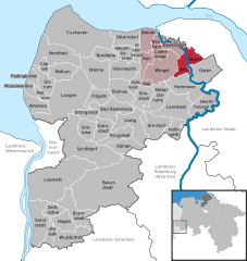
- Oberndorf, Lower Saxony
-
Oberndorf 
Coordinates 53°45′0″N 9°09′0″E / 53.75°N 9.15°ECoordinates: 53°45′0″N 9°09′0″E / 53.75°N 9.15°E Administration Country Germany State Lower Saxony District Cuxhaven Municipal assoc. Am Dobrock Mayor Detlef Horeis (SPD) Basic statistics Area 32.71 km2 (12.63 sq mi) Elevation 1 m (3 ft) Population 1,444 (31 December 2010)[1] - Density 44 /km2 (114 /sq mi) Other information Time zone CET/CEST (UTC+1/+2) Licence plate CUX Postal code 21787 Area codes 04771, 04772, 04778 Website www.oberndorf-oste.de Oberndorf is a municipality in the district of Cuxhaven, in Lower Saxony, Germany.
Oberndorf upon Oste belonged to the Prince-Archbishopric of Bremen, established in 1180. In 1648 the Prince-Archbishopric was transformed into the Duchy of Bremen, which was first ruled in personal union by the Swedish Crown - interrupted by a Danish occupation (1712–1715) - and from 1715 on by the Hanoverian Crown. The Kingdom of Hanover incorporated the Duchy in a real union and the Ducal territory became part of the new Stade Region, established in 1823.
Armstorf · Bad Bederkesa · Belum · Beverstedt · Bramstedt · Bülkau · Cadenberge · Cappel · Cuxhaven · Dorum · Drangstedt · Driftsethe · Elmlohe · Flögeln · Geversdorf · Hagen im Bremischen · Hechthausen · Hemmoor · Hollnseth · Ihlienworth · Köhlen · Kührstedt · Lamstedt · Langen · Lintig · Loxstedt · Midlum · Misselwarden · Mittelstenahe · Mulsum · Neuenkirchen · Neuhaus · Nordholz · Nordleda · Oberndorf · Odisheim · Osten · Osterbruch · Otterndorf · Padingbüttel · Ringstedt · Sandstedt · Schiffdorf · Steinau · Stinstedt · Uthlede · Wanna · Wingst · Wremen · Wulsbüttel
References
- ^ "Bevölkerungsfortschreibung" (in German). Landesbetrieb für Statistik und Kommunikationstechnologie Niedersachsen. 31 December 2009. http://www1.nls.niedersachsen.de/statistik/html/parametereingabe.asp?DT=K1000014&CM=Bev%F6lkerungsfortschreibung.
Categories:- Municipalities in Lower Saxony
- Lüneburg region geography stubs
Wikimedia Foundation. 2010.


