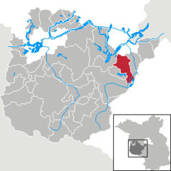
- Michendorf
-
Michendorf 
Coordinates 52°18′N 13°01′E / 52.3°N 13.01667°ECoordinates: 52°18′N 13°01′E / 52.3°N 13.01667°E Administration Country Germany State Brandenburg District Potsdam-Mittelmark Local subdivisions 6 Ortsteile Mayor Cornelia Jung (Ind.) Basic statistics Area 68.51 km2 (26.45 sq mi) Elevation 45 m (148 ft) Population 11,805 (31 December 2010)[1] - Density 172 /km2 (446 /sq mi) Other information Time zone CET/CEST (UTC+1/+2) Licence plate PM Postal code 14552 Area code 033205 Website www.michendorf.de Michendorf is a municipality in the Potsdam-Mittelmark district, in Brandenburg, Germany.
Geography
The municipality is composed by Michendorf itself and 5 civil parishes (Ortsteile). Statistics of population are as of December 31, 2009 [2]
- Michendorf (4.193)
- Fresdorf (303)
- Langerwisch (1.772)
- Stücken (482)
- Wildenbruch (1.851)
- Wilhelmshorst (2.984)
References
- ^ "Bevölkerung im Land Brandenburg am am 30. Dezember 2010 nach amtsfreien Gemeinden, Ämtern und Gemeinden. Gebietsstand: 31.12.2010" (in German). Amt für Statistik Berlin-Brandenburg. 31 December 2010. http://www.statistik-berlin-brandenburg.de//Publikationen/OTab/2011/OT_A01-04-00_124_201012_BB.pdf.
- ^ (German) Infos on the official website of Michendorf
Bad Belzig | Beelitz | Beetzsee | Beetzseeheide | Bensdorf | Borkheide | Borkwalde | Brück | Buckautal | Golzow | Görzke | Gräben | Groß Kreutz | Havelsee | Kleinmachnow | Kloster Lehnin | Linthe | Michendorf | Mühlenfließ | Niemegk | Nuthetal | Päwesin | Planebruch | Planetal | Rabenstein | Rosenau | Roskow | Schwielowsee | Seddiner See | Stahnsdorf | Teltow | Treuenbrietzen | Wenzlow | Werder | Wiesenburg | Wollin | Wusterwitz | ZiesarCategories:- Municipalities in Brandenburg
- Brandenburg geography stubs
- Localities in Potsdam-Mittelmark
Wikimedia Foundation. 2010.


