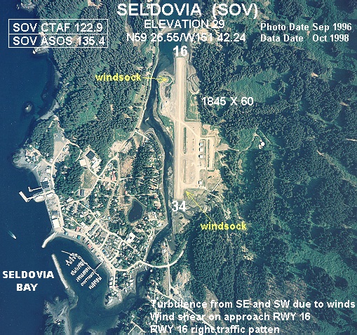
- Seldovia Airport
Infobox Airport
name = Seldovia Airport

caption =
IATA = SOV
ICAO = PASO
FAA = SOV
type = Public
owner =
operator = State of Alaska DOT&PF
city-served =
location =Seldovia, Alaska
elevation-f = 29
elevation-m = 9
coordinates = coord|59|26|33|N|151|42|15|W|type:airport|display=inline
website =
r1-number = 16/34
r1-length-f = 1,845
r1-length-m = 562
r1-surface =Gravel
stat-year = 2005
stat1-header = Aircraft operations
stat1-data = 5,660
stat2-header = Based aircraft
stat2-data = 15
footnotes = Source:Federal Aviation Administration FAA-airport|ID=SOV|use=PU|own=PU|site=50693.*A, retrieved 2007-03-15]Seldovia Airport Airport codes|SOV|PASO|SOV [ [http://gc.kls2.com/airport/SOV Great Circle Mapper: SOV / PASO - Seldovia, Alaska] ] is a public
airport located one mile (2 km) east of thecentral business district of Seldovia, in Kenai Peninsula Borough,Alaska ,United States . This airport is publicly owned by the State ofAlaska Department of Transportation and Public Facilities (DOT&PF) - Central Region.Facilities and aircraft
Seldovia Airport covers an area of 177
acre s (72 ha) which contains one gravelrunway (16/34) measuring 1,845 x 60 ft (562 x 18 m).For 12-month period ending December 31, 2005, the airport had 5,660 aircraft operations, an average of 15 per day: 62% general aviation and 38% air taxi.
There are 15 aircraft based at this airport: 93% single engine and 7% multi engine.
References
External links
* [http://www.alaska.faa.gov/fai/images/ARPT_DIAGRAMS/SOV.gifAirport Diagram] (
GIF )
Wikimedia Foundation. 2010.
