DePuy Spring Creek

DePuy Spring Creek
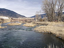
Upper Section of DePuy Spring Creek, January 2008

Coordinates: 45°33′43″N 110°35′25″W / 45.56194°N 110.59028°W / 45.56194; -110.59028 (DePuy Spring Creek) DePuy Spring Creek is a three mile long trout fishery located between the Absaroka and Gallatin mountain ranges in Paradise Valley, south of Livingston, Montana. The creek is a small tributary of the Yellowstone River. This fishery supports a population of brown, cutthroat and rainbow trout.[1]

References

  • Walinchus, Rod; Travis, Tom (1995). Fly Fishing The Yellowstone River. Boulder, CO: Pruett Publishing. ISBN 0871088614. 
  • Hughes, Dave (1992). The Yellowstone River and its Angling. Portland, OR: Frank Amato Publications. ISBN 1878175238. 
  • Graetz, Rick; Graetz, Susie (2002). Montana's Yellowstone River - From the Teton Wilderness to the Missouri. Helena, MT: Northern Rockies Publishing. ISBN 1891152165. 
  • Ford, Pat (2007). Best Fly-Fishing Trips Money Can Buy. Mechanicsburg, PA: Stakepole Books. ISBN 0811701794. 

Notes


Wikimedia Foundation. 2010.

Игры ⚽ Нужен реферат?

Look at other dictionaries:

  • Spring creek — This article is about the hydrological feature. See Spring Creek for specific places named Spring Creek. A spring creek is a type of free flowing river whose name derives from its origin: an underground spring or set of springs which produces… …   Wikipedia

  • List of fly fishing waters in North America — The articles listed below on specific bodies of water seas, lakes, rivers, etc. have significant content on the subject of fly fishing for the fish that swim in them or are notable fly fishing destinations in North America.United States* Alaska… …   Wikipedia

  • Yellowstone River — The Yellowstone River is a tributary of the Missouri River, approximately 671 miles (1,080 km) long, in the western United States. Considered the principal tributary of the upper Missouri, the river and its tributaries drain a wide area… …   Wikipedia

  • List of fishing topics — This page is a list of fishing topics. AlphanumericTOC align=center nobreak= numbers= seealso= externallinks= references= top=| 11959 Escuminac Hurricane22004 Morecambe Bay cockling disasterAA Pobra do Caramiñal A River Somewhere Abalone ABU… …   Wikipedia

  • Connecticut River — Coordinates: 41°16′20″N 72°20′03″W / 41.27222°N 72.33417°W / 41.27222; 72.33417 …   Wikipedia

  • Paradise Valley (Montana) — Infobox Settlement name = Paradise Valley latd = 45 | latm = 23 | lats = 47 | latNS = N longd = 110 | longm = 44 | longs = 9 | longEW = W coordinates type = type:river:1000000 coordinates display = inline,title Paradise Valley is situated in… …   Wikipedia

  • List of fishing topics by subject — This page is a list of fishing topics by subject. Most fishing articles have a side bar at the top right. This page mirrors the topics in the side bars. See also: List of fishing topics and Fisheries glossary   Contents:… …   Wikipedia

  • 1st Infantry Division (United States) — Infobox Military Unit unit name=1st Infantry Division caption=1st Infantry Division shoulder sleeve insignia country=United States allegiance= type=Division branch=Regular Army dates=May 24, 1917 specialization=Heavy Mechanized command… …   Wikipedia

  • Ocean Beach, San Diego — Ocean Beach, California redirects here. For the beach in San Francisco, see Ocean Beach, San Francisco, California. Coordinates: 32°45′3.18″N 117°15′6.13″W / 32.7508833°N 117.2517028°W …   Wikipedia

Share the article and excerpts

Direct link
Do a right-click on the link above
and select “Copy Link”