Ötvöskónyi

Ötvöskónyi
Ötvöskónyi
Country  Hungary
County Somogy
Area
 – Total 27.71 km2 (10.7 sq mi)
Population (2004)
 – Total 921
 – Density 33.23/km2 (86.1/sq mi)
Time zone CET (UTC+1)
 – Summer (DST) CEST (UTC+2)
Postal code 7511
Area code(s) 82

Ötvöskónyi is a village in Somogy county, Hungary.

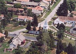
Aerialphotography of Ötvöskónyi


External links

Coordinates: 46°17′16″N 17°21′38″E / 46.28778°N 17.36051°E / 46.28778; 17.36051


Wikimedia Foundation. 2010.

Игры ⚽ Поможем написать реферат

Look at other dictionaries:

  • Ötvöskónyi — Administration …   Wikipédia en Français

  • Somogy County — Infobox Hungarian county name =Somogy region =Southern Transdanubia seat = Kaposvár area = 6036 population = 325.024 density = 54 cities = 244Somogy is the name of an administrative county (comitatus or megye) in present Hungary, and also in the… …   Wikipedia

  • Csurgó — For the Romanian village of Ciurgău, called Csurgó in Hungarian, see Ceanu Mare. Csurgó Country  Hungary County Somogy Area …   Wikipedia

  • Marcali — Marcali …   Wikipedia

  • Nagyatád — Nagyatád …   Wikipedia

  • Nagybajom — Nagybajom …   Wikipedia

  • Kleingebiet Nagyatád — Das Kleingebiet Nagyatád ist eine ungarische Verwaltungseinheit innerhalb des Komitat Somogy in Westungarn. Der Verwaltungssitz ist Nagyatád. Ortschaften Die folgenden Ortschaften gehören zum Kleingebiet Nagyatád: Bakháza Beleg Bolhás Görgeteg… …   Deutsch Wikipedia

  • Balatonföldvár — Administration …   Wikipédia en Français

  • Barcs — Héraldique Administration …   Wikipédia en Français

  • Siófok — Héraldique Administrati …   Wikipédia en Français

Share the article and excerpts

Direct link
Do a right-click on the link above
and select “Copy Link”