Thelwall Viaduct

Thelwall Viaduct

Infobox_Bridge
bridge_name=Thelwall Viaduct


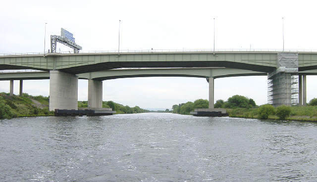
caption=Thelwall Viaduct
official_name=Thelwall Bridge
carries=M6
crosses=Manchester Ship Canal
locale=Thelwall, a district of Warrington, England
maint=
id=
design= Girder Bridge
mainspan=102.4m
length=1.35km
width=
height=
load=
clearance=
below=
traffic=
open=1963
closed=
toll=None
troll=
map_cue=
map_

map_text=
map_width=
coordinates= coord|53.3906|-2.5059|type:landmark_scale:2000_region:GB
lat=53.3906
long=-2.5059

The Thelwall Viaduct (gbmapping|SJ664883) is a steel composite girder viaduct in Thelwall, a district of Warrington, England. It carries the M6 motorway across the Manchester Ship Canal and the River Mersey. Its location on the motorway network is between junctions 20 and 21 of the M6, the former being also known as junction 9 of the M56.

It actually comprises two entirely separate bridges, one carrying the northbound carriageway (opened in July 1963) and one the southbound carriageway (opened in 1995). Both viaducts are approximately 1.35 km long, with the longest span being 102.4 m over the Ship Canal. [http://homepages.tesco.net/frankshackleton/mscbridges/section7/section7.htm Bridges of the Manchester Ship Canal] , accessed on 5 June 2007]

The Thelwall Viaduct became notorious in July 2002, when a failed roller bearing was discovered and it became necessary to close all but one northbound lane. As the M6 at the time carried an estimated 150,000-160,000 vehicles per day, this led to serious congestion. [UK Parliament|date=14 April 2003|place=Written Answers|speaker=David Jamieson|column=600W|url=http://www.theyworkforyou.com/wrans/?id=2003-04-14.108894.h|title=Transport - Thelwall Viaduct] The viaduct was not completely reopened to daytime traffic until February 2005, and subsequently remained partially closed at night for further remedial work to take place. [cite web|url = http://news.bbc.co.uk/1/hi/england/manchester/4242437.stm|title = BBC News: M6 viaduct reopen after repairs] In all, 148 bearings were replaced, with the repair scheme costing £52 million.

External links

* [http://www.iht.org/motorway/m6prewar.htm The Motorway Archive website]

References


Wikimedia Foundation. 2010.

Игры ⚽ Нужно сделать НИР?

Look at other dictionaries:

  • Thelwall — infobox UK place official name= Thelwall map type= Cheshire latitude= 53.382400 longitude= 2.530873 os grid reference= SJ647874 population = 9,377 civil parish= Grappenhall and Thelwall unitary england= Warrington country = England lieutenancy… …   Wikipedia

  • Liste des ponts du Royaume-Uni — Liste de ponts du Royaume Uni Cette liste de ponts du Royaume Uni recense les ponts les plus remarquables du fait de leurs caractéristiques dimensionnelles ou de leur intérêt architectural ou historique en Angleterre, en Écosse, au Pays de Galles …   Wikipédia en Français

  • Manchester Ship Canal — The Stolt Kittiwake heading toward the Mersey Estuary, 2005 Principal engineer Edward Leader Williams Date of act …   Wikipedia

  • List of bridges in the United Kingdom — Bridges in the United Kingdom is a link page for any non railway bridge in the United Kingdom.Railway bridges are listed under: List of railway bridges and viaducts in the United Kingdom.England*Bridge of Sighs (Cambridge) *Bridge of Sighs… …   Wikipedia

  • Cheshire — For other uses, see Cheshire (disambiguation). Cheshire …   Wikipedia

  • M6 motorway — UK motorway routebox motorway= M6 length mi= 226.7 length km= 364.8 direction= North South start= Catthorpe destinations= Rugby Coventry Nuneaton Birmingham Walsall Wolverhampton Stafford Stoke on Trent Warrington Manchester Liverpool Preston… …   Wikipedia

  • Cheshire Constabulary — Logo of the Cheshire Constabulary. Agency overview Formed …   Wikipedia

  • List of Statutory Instruments of the United Kingdom, 1990 — NOTOC This is a complete list of all 1646 Statutory Instruments published in the United Kingdom in the year 1990.1 100* Caseins and Caseinates (Scotland) Amendment Regulations 1990 S.I. 1990/1 * Personal Community Charge (Relief) (England)… …   Wikipedia

  • Kyrill (storm) — Kyrill (IPA2| kɪrɪl) is the name given to a low pressure area that evolved into an unusually violent European windstorm, forming an extratropical cyclone with hurricane strength winds. It formed over Newfoundland on 15 January, 2007 and moved… …   Wikipedia

  • Motorway M6 — Vorlage:Infobox hochrangige Straße/Wartung/GB M M6 motorway im Vereinigten Königreich …   Deutsch Wikipedia

Share the article and excerpts

Direct link
Do a right-click on the link above
and select “Copy Link”